Pages

Friday, June 21, 2024

Redwood National and State Parks in Northern California, October 2023

When we traveled the Oregon Coast in the Fall of 2016, we had hoped to continue into northern California to Redwood National Park, but the weather turned very nasty, so we went inland instead. This year, on our way from western Canada to Pismo Beach on the central California Coast, the weather was much nicer so we were able to visit some of our bucket list places. Our first stop was Crescent City, where we stayed for free at the new Elk Valley Casino for three nights.

Howland Hill Road


Not far up Howland Hill Road beyond Crescent City, we found ourselves deep in the redwood forest. These giants are always amazing. 

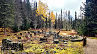
Brad poses beside a redwood stump.

At the end of the road, we take the Stout Memorial Grove Trail. Brad is kneeling beside a fallen redwood, with the upended roots of a fallen tree beside him.

Klamath River


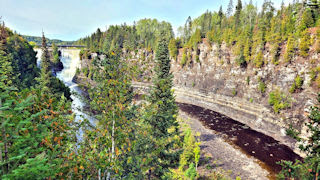
Just south of Crescent City is the town of Klamath and the Klamath River. From the Klamath River Overlook, you can see the river on the left of the sand spit, and the Pacific Ocean on the right.

From the overlook, we returned to Highway 101, crossed the Klamath River and followed Klamath Beach Road to the river outlet. Here, harbor seals were basking and swimming, making for a great show. The river was running very fast too, a current I would not want to be caught in, but the seals were having fun.

Smith River


North of Crescent City, the Smith River lets out into the ocean at Pyramid Point. We spent a day just sitting and enjoying the view and the seals.  There is a small parking lot behind me, and a small beach below the bushes.

On the way home, we came upon two male elk fighting. Fall is rutting season, and we saw many herds of elk in our northern and central California travels. These warriors were at a campground along Highway 101, where the campers and female elk were calmly watching. They put on quite the show.

Crescent City


Crescent Beach is a 3-mile stretch of sand with Crescent City at the northern end. This view is from Crescent Beach Overlook on Enderts Beach Road.

Battery Lighthouse is accessible during low tides. We walked out to the island and toured around the building, which was unfortunately closed. Like most lighthouses, this one is now automated.  The one thing we did have to endure while camped at the casino was a fog horn that sounded about every 8 seconds.  Honestly though, we got used to it quickly and it didn't bother us.

The tide pools around the lighthouse were full of sea stars - red ones and orange like this one pictured. Many people were braving the slippery rocks to investigate with the low tide.


Monday, June 17, 2024

Mount St. Helen's in Washington, October 2023


After leaving BC and Canada, we crossed into the U.S. from Osoyoos, B.C. to Oroville, Washington. On our way to Mount St. Helen's, we pass by this incredible view of Mount Ranier.

I have wanted to visit Mount St. Helen's for a long time now, but we are never in Washington, although here we were passing through on our way to California! However, a scan on the Mount St. Helen's National Volcanic Monument website indicated that the Visitor Center and the best two areas from which to view the crater were all closed due to mud slides closing the roads. Not to be discouraged, we camped in the town of Cougar, and drove up National Forest Road 83 to the Lava Canyon Trailhead. Just before the parking lot, we scooped this view of the southeast side of Mount St. Helen's. The eruption in 1980 was on the north side, so we are unable to see the crater that was formed. There is also a nice view from the Lahar Viewpoint Parking Lot.

The Muddy River from a bridge on the Lava Canyon Trail. This was a nice, easy trail to hike, although the suspension bridge lower in the gorge was washed out and closed, making the loop hike impossible.

Ape Cave is a lava tube, worthy of exploration. We purchased tickets in advance online. The cave was created about 2,000 years ago from an eruption near the summit of Mount St. Helen's.

Marilyn taking in the sheer size of Ape Cave. Hard to believe that 2,000 years ago, this tube was full of fluid basalt flowing like a river. I highly recommend this self-guided hike. There is also a nice gift shop on-site, and a volunteer who is very knowledgeable about the cave and can answer almost any question.


British Columbia National Parks, Fall 2023

In mid-October, we visited all four of the national parks in the Rocky Mountains of BC, as well as Banff National Park in western Alberta. We also stopped in at the soaking pools of Radium Hot Springs. I was expecting something very different, not the huge shallow swimming pools that are there. We didn't soak, but many people were there to do so in the lovely forested setting.

Kootenay National Park


We were excited to get into the Rockies, but fall is here (it's after the Canadian Thanksgiving) and most park campgrounds are closed. So we looked for other options near Invermere or Radium Hot Springs, and were very happy to get info from a local about free camping at the Lake Enid Recreation Site. This is a view of Lake Enid, not from our campsite, but only a short stroll away. The road in is pretty rough, but we're adventurous and willing to get away from crowds.

We drove into Kootenay National Park from Radium Hot Springs. The entire drive along the Kootenay Highway (Hwy 93) is stunning. This stop is at the Numa Creek Trailhead parking lot, although this is the Kootenay River. Nothing beats the colour of the glacial waters in the mountains.

Our day trip ended at the Marble Falls Trail. Hiking up from the highway, the clear waters pool, surrounded by evergreens. As we climb higher, a chasm forms with the Kootenay River far below, sometimes so far it is dark. I forget how many waterfalls there were, and some were thunderous. The trail criss-crosses the chasm with wooden bridges.  This photo shows Brad at the end of the developed trail.

On the way back, we stopped at Vermillion Crossing and hiked the Kootenay River a short distance to the east.

Yoho National Park


At our previous campsite at Lake Enid, we met a local native, Little Bear, who has explored these mountains fairly extensively. He told us where we could boondock (camp for free without hookups) near the town of Golden. This was our view on the Blaeberry River, about a 10-15 minute drive off the highway. There were a few other campers here as well, but camping beside the river and hearing the water trickling over the rocks all night was the best peace in the world!

Yoho National Park is to the east of Golden, and we took a couple of day trips through the park. Here is Emerald Lake Lodge on - you guessed it - Emerald Lake.

On the way home one evening, we spotted several cars pulled over on the side of the highway, so I knew some wildlife was nearby. This grizzly bear was sauntering down the train tracks. It's time to find a den for the winter Grizz!

Natural Bridge in Yoho National Park is a very popular spot with tourists. The Kicking Horse River runs along the Trans-Canada Highway for some distance before cascading through this natural bridge just off of Emerald Lake Road. A trail follows the river downstream for a short distance. Also interesting and just east of this spot is the spiral tunnel, where trains quickly gain or lose elevation by going through a circular tunnel inside the mountain. No photo here as it would be too small to see the train or the tunnel, although we were lucky to see a train passing.

Banff National Park in Alberta


Since Lake Louise was so close to the eastern entrance of Yoho National Park, we decided to take a quick drive there. Lake Louise never disappoints, but it can be crowded, more-so in summer, I'm sure.

Glacier and Mount Revelstoke National Parks


Glacier and Mount Revelstoke National Parks are to the west of us, and we decide to sample both in one day. In Glacier National Park, we hiked the Meeting of the Waters Trail. It was a very wet day, not raining, but misty. I think we would have enjoyed this easy hike more if it was drier and sunny.

Along the way was the ruins of an old hotel called Glacier House, which was one of three stops along the Canadian Pacific line. This hotel was once a sister to the Banff Springs Hotel and Chateau Lake Louise, both of which are now quite famous and still in use. Glacier House is in ruin due to its abandonment after avalanches hit the area in 1910, and a decision to tunnel the train track through the mountain instead. A good history of Glacier House and the proposed railway line is here.

In Mount Revelstoke National Park, we drove up the Meadows in the Sky Parkway. The cloudy sky opened up briefly for this lovely shot of the town of Revelstoke and the Columbia River. There were many stops along this parkway, affording views of the valley, river and surrounding mountains, as well as hiking trails.


Sunday, June 9, 2024

Alberta Parks, Fall 2023

Red Rock Coulee


Continuing west, our next destination was Writing-on-Stone Provincial Park, but it was too long a drive for one day. So I wanted to find somewhere interesting to stay overnight that wasn't far off our path. I found Red Rock Coulee. It has a small parking lot, and staying overnight is okay. In fact, two other van campers stayed while we were here. Below the parking lot is an area full of these round red rocks.

As I was walking the cat around outside allowing her to stretch her legs after the long drive, I saw this Prairie Rattler slithering through the long grass. Trixie didn't see it, and I quickly put her inside (me too!) Brad took photos of the snake, and we were thinking of relocating it farther away from our truck and trailer, but decided to leave it alone. It didn't bother us the rest of the night.

Writing-on-Stone Provincial Park


Writing-on-Stone Provincial Park is an absolute gem! The campground is along the Milk River below a ridge of hoodoos.

The park is known for its petroglyphs. These are visible on the Battle Scene Trail. Other petroglyphs required a guided tour from the Visitor Centre.

A view of the Milk River and a reconstructed North West Mounted Police Post. West Butte in Montana is the mountain visible in the background.

Dinosaur Provincial Park


We wanted to go to Waterton Lakes National Park in the southwest corner of Alberta, but the weather there wasn't good, so we decided to go north to Dinosaur Provincial Park to buy some time. More hoodoos, and dinosaur bones. This view is from the Badlands Trail. There are four main trails in the park, with two outdoor fossil displays accessed on the scenic loop road.

The Visitor Centre has many fossils displayed, and descriptions of the dinosaurs found in this area. The Royal Tyrell Museum is much farther north in Drumheller, and has many wonderful displays of dinosaurs. We did not go there as we had been there before in 2005.

Thunderheads brewing near the Red Deer River, which runs through the park.

Waterton Lakes National Park


The weather had cleared, so we headed back south to Waterton Lakes National Park. I can't say enough wonderful things about this park. This was our campsite at the Townsite Campground. Spectacular views.  I like this park better than Banff National Park because it is just as beautiful, surrounded by the Rocky Mountains, but much less crowded.

The Prince of Wales Hotel was under renovation while closed for the season. Sitting atop a knoll, it looks southward down the entire length of Upper Waterton Lake. The southern end of this lake is in Glacier National Park in Montana.

Red Rock Canyon is a beautiful creek that flows through red rock. From the parking lot, we followed the path up the creek where the walls of the chasm deepened into a steep canyon about 100 feet deep (I'm guessing). A bridge crosses the creek and a path follows it back down on the opposite side from the parking lot, making a loop trail.  From here, we also hiked to Blakiston Falls, but photos were difficult to get.  The trail was easy and the waterfall worth seeing.

The view looking south on the shores of Cameron Lake. We hiked the trail along the water to Grizzly's Garden. We kicked ourselves for not bringing our kayaks that day as many folks were paddling on the still water. Like Upper Waterton Lake, the southern end of Cameron Lake is in Glacier National Park in Montana.

Brad posing with a drill bit from Western Canada's first oil well at the historic monument.

Cameron Falls behind our campground.


Grasslands National Park and Cypress Hills Interprovincial Park in Saskatchewan, September 2023

First stop after Ontario was Whiteshell Provincial Park in Manitoba just barely across the border. We stayed at the campground at West Hawk Lake, which was created by a meteor and is the province's deepest lake. It is frequented by scuba divers, many of whom were also camped in the campground. We did drive around the area a bit, but it was very rainy and we decided to shorten our stay here and push through to Saskatchewan where the weather was more favourable.

Grasslands National Park


We drove for an entire day to Grasslands National Park in the southwest of Saskatchewan. This park is divided into two sections - East Block and West Block. We stayed in the East Block at Rock Creek Campground. This photo was taken from the Badlands Parkway, an 11 km road overlooking Rock Creek and scenic vistas. We decided not to visit the West Block, assuming it was very similar.

Cypress Hills Interprovincial Park


On the southern border of Saskatchewan and Alberta, we visited Cypress Hills Interprovincial Park. After driving across the flat prairies of Manitoba and Saskatchewan, these hills are a welcome sight. We camped in the Meadows Campground, and drove to Lookout Point, pictured here, before sunset.

We cycled around the park, which is quite large, and found this serene spot at the north end of Lock Leven. The park has many hiking and cycling trails, as well as a swimming pool, golf course, mini-putt, resort lodge, cabins, restaurant, and about 12 campgrounds. It is a very popular summer destination for locals. We thoroughly enjoyed staying here.

For a day trip, we drove west on the Gap Road (a dirt road that is easily accessible by any vehicle, depending on the weather), and came across a herd of horses. They weren't wild horses, as they were much too friendly, especially this one that I'm petting. When we got back in the truck to continue, both of these horses stood in front of the truck with their chins on the hood, preventing our departure. I had to get back out and lead them off the road so we could drive away. Such sweeties.

This is Fort Walsh National Historic Site. It was built in the 1870s by the North West Mounted Police to bring law and order to the Canadian West following the Cypress Hills Massacre, an attack on the Native People by American wolf hunters.


Saturday, June 8, 2024

Lake Superior in Ontario, September 2023

In early August 2023, we decided to take an extra month for our 2023-2024 Snowbird journey, and travel across Canada first. Usually our trips are 6 months and are spent entirely in the U.S. Southwest. But it was time for something different. But with the summer half over, this didn't leave much time to get ready because we would leave right after labour day to capitalize on the good fall weather. A route was planned, destinations were chosen, reservations were made, and we left on September 8th! First stop - Lake Superior.

Lake Superior Provincial Park


We camped at Lake Superior Provincial Park's Rabbit Blanket Campground, and drove north on the Trans-Canada Highway to Old Woman Bay. Here I am in the bay, touching Lake Superior for the first time ever!  The beach here was quite long, with a creek draining into the lake.

Brad at the Katherine Cove Picnic Area. The rocks under the water were beautifully striped.  From the beach, you can hike the Coastal Trail, although we did not as our time was limited.

The most accessible waterfalls in the park are Sand River Falls. There were several waterfalls which we hiked up the river to see. This is a gorgeous spot to spend a picnic lunch.  Sand River drops 600 feet (185 m) in elevation between Sand Lake and Lake Superior.

Pukaskwa National Park


Our second camping spot was at Pukaskwa National Park. This photo is at the start of the Southern Headland Trail. I did hike out to the point for a lovely view of this bay.  Unfortunately, we had rainy weather while we were here.

I would have loved to hike to the White River Suspension Bridge, but it is a long 11 mile (18 km) full day hike, and we're just not up to that anymore.

Kakabeka Falls Provincial Park


Never to be missed when traveling across the Trans-Canada, Kakabeka Falls is second in height only to Niagara Falls.  The water thunders over the ledge of rocks.  There are trails on both sides of the river, allowing for nice views of the Falls.

View of Kakabeka Falls, the Kaministiquia River, and the gorge from the Mountain Portage Trail.

A serene pond on the Beaver Meadow Trail, which we cycled from the campground.

And yes, we saw the Wawa goose, and the Kenora fish (Husky the Muskie), but I took no pictures.