Blog Resurrection ...
I haven't updated this Blog in seven years, and we have been to so many NEW places in these past years that it seems prudent to do so now.
The White Rim Road is a checked Bucket List trip. Campsites and a road permit have to be pre-booked months in advance. We drove this 100 mile long primitive road with friends Paul and Sue who drove their Jeep, and Dolores in her Dodge RAM 4x4. Campsites are also primitive, which means sleeping in a tent, something I haven't done in many, many years. But I was willing to put my comfort aside for this trip of a lifetime.
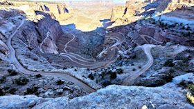
| This is the Shafer Trail which is one way of accessing the White Rim Road from the Visitor Centre in Canyonlands National Park. We drove in from Moab on the Potash Road, and exited 3 days later on Mineral Bottom Trail. You can choose which direction to drive the road, just know that many sections are single-lane. | |
| The view from Potash Road heading towards the White Rim Road. | |
| Near Thelma and Louise Point and below Dead Horse Point State Park, a view of the Green River (which isn't so green here) along the Potash Road. | |
| It's a long way down. The White Rim Road sits about half way between the Islands in the Sky District of Canyonlands National Park which is about 800 feet above and the Green River some 800 feet below. I know this photo is small, but maybe you can see our two vehicles parked in the crescent of the overhang, and some of our group standing there also. | |
| Setting up camp for our first night at Gooseberry Campground A. We have an amazing view of the snow-capped Manti-Las Sal Mountains at sunset. This first night was freezing, going down to 28F or -2C. And my air mattress deflated in the middle of the night so I ended up sleeping on the slickrock. All part of the experience, right? | |
| This rock has eroded with what looks like two hammers on either end. | |
| Storm clouds developed as we were setting up camp on our second night at Candlestick Campground. The sun is setting causing the red rocks to glow against that dark, cloudy backdrop. Spectacular. We did get a light sprinkle in the night, and the winds picked up, and it was still really cold, but we survived, and the scenery made it worthwhile. | |
| Paul in his Jeep going up the Murphy Hogback. This was on the last day and while the ascent and descent were steep, it was not extremely difficult. Hardscrabble Hill was more scary with its tight switchbacks and steep dropoffs. | |
| The road had finally descended to the Green River, and we had this lovely view. We averaged about 11 mph or 18 kph overall during the 3-day drive. Much of it is very bumpy over slickrock, with some sandy stretches. | |
| More views from the Island in the Sky District of Canyonlands National Park showing the White Rim Road (if you can see it on the left between the two eroded canyons). | |
| The White Rim Road might be slightly more visible in this photo as it comes from the bottom left and skirts the eroded canyons as it continues to the top right. Photo was also taken from Island in the Sky. |
While I thoroughly enjoyed this trip, for me it was tough. Sleeping in a tent in freezing cold weather, bumping along in a pick-up truck all day, rushing to get to our reserved campsite and set up our gear before dark were all part of the adventure. I think we could have used one more day to better explore some of the side roads and hikes along the way. However, I wouldn't do it again, but I am glad I did it. Bucket List Trip - CHECK!


No comments:
Post a Comment