First stop is Los Alamos, a small town perched atop a mesa in the beautiful Jemez Mountains and made famous by the Manhattan Project in the 1940s. I keep hearing Sting singing "How can I save my little boy, from Oppenheimer's deadly toy?" as it was here that the world's first atomic bomb was built in utter secrecy by a large team of brilliant scientists lead by J. Robert Oppenheimer. While I knew that the Manhattan Project started here in Los Alamos, I didn't realize that the Los Alamos is the center for the country's National Laboratory, which is responsible for developing new technologies for defense, space exploration, medical advancements, and more. The Bradbury Science Museum showcases the LANL's history (beginning with the Manhattan Project) and current work. Brad and I even attend a one-hour lecture on explosives given by LANL staff. Pretty scientific stuff, but the chemistry and pyro-techniques are right up Brad's alley. Here's what I remember - the LANL is responsible for the development of nearly cloudless fireworks, useful for theme parks who thrill guests with a fireworks show nightly but are mindful of air quality.
The museum includes many hands-on exhibits about nuclear weapons, WWII, space science including the Mars rover, radiation, nanotechnology, and more. It is like being back in school and our brains are exhausted after spending several hours watching the films and wandering the exhibits. While photography is allowed, we don't take any photos in the museum. If you're interested, check out their website which
includes a link to the movie "The Town That Never Was" on YouTube that explains the history of the Manhattan Project.
We also visit the Valles Caldera (pron. VIE-ez), the sunken cone of the dormant Jemez (HEY-mess) super-volcano. The caldera is 12 miles in diameter (hence the reason it's a super-volcano and not just a volcano) and is now a beautiful meadow that feeds cattle and herds of elk.
Bandelier National Monument is a large federal park on the side of the ancient Jemez Volcano. It is where we camp. The main part of the park is in Frijoles (pron. Fri-HOLE-ays) Canyon, which was devastated by flooding during the recent torrential rains. By our third day here, the park is finally open and we tour the ancient cliff dwellings of the native pueblo peoles. We join a ranger-led guided tour; our guide is a Cochiti Pueblo Indian (they still us the term "Indian" here) and shares many native stories with us. She makes the tour so much more enjoyable.
| Valle Grande, overlooking the Valles Caldera. There are elk and cattle grazing, but too small to see in the photo | |
| A cool, unidentified lizard we meet at the White Rock Overlook Park | |
| Brad at the White Rock Overlook Park, high above the muddy Rio Grande | |
| Marilyn following the path of the Ancients at Tsankawi, an ancient Pueblo. These paths were worn by the natives travelling along the rock cliffs. | |
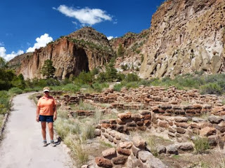
| Marilyn at the ruins in Frijoles Canyon, Bandelier National Monument. Some people lived in the valley near the river, and others in cliff dwellings above to the right. | |
| Brad in front of Long House, a 1/4 mile long series of cliff dwelling ruins | |
| The remaining walls of the valley village at Bandelier National Monument from the cliff dwellings | |
| Some of the destruction caused by the floods of last week, along the Frijoles Creek near the Visitor Center at Bandelier National Monument. Rangers say that the water rose over 13 feet! |


Love seeing pictures of you two enjoying.
ReplyDelete