Monday, October 21, 2013

Cottonwood Canyon, UT

We leave New Mexico (Land of Enchantment) and head to Page, Arizona (The Grand Canyon State) on Lake Powell, by-passing Canyon de Chelly thanks to the US Government Shutdown and the closure of most national parks.  In Page, we shop for supplies and plan to head to the Vermillion Cliffs National Monument, but discover (by chatting with my Walmart hair dresser!) that the highway that will take us there (#89) collapsed in February!  We've driven this highway a couple of times over the past years, and this cut is extremely long, perched on the edge of a cliff overlooking the canyons of the Colorado.  It's fortunate the collapse happened in the middle of the night and no one was injured.

So, re-route to southern Utah (The Beehive State [what?]) and from whose border Page is only a few miles to explore some areas we didn't get to last year.  Cottonwood Canyon Road, where we spend nine days, is in the Grand Staircase-Escalante National Monument, one of our all-time favourite places.

First, let me say that we've never seen the desert so green - and yellow, red, orange and purple. Thanks to the recent rains (remember the flooding in Colorado and New Mexico?), desert wildflowers have started to bloom and the usual vegetaion is dark green having soaked up that moisture. It's a beautiful sight.
This area along the Cockscomb was full of these tiny yellow flowers.
Of course in these parts, with rain comes also washed-out dirt roads. Brad is standing in a part of a dirt road beside Coyote Creek (now dry) that was destroyed - it's over a 6-foot drop here, and other parts of roads we saw were worse! We parked and hiked the last 1/2 mile!
Our first adventure takes us down BLM Road 431 on which we are camped, to "White Rocks" - at least that's what it says on the map. It's one of those times we don't have a destination in mind, we just wonder "what's down this road?" It's a real challenge too and our truck is barely able to make some of the, now dry, creek crossings which are still damaged from the rains of September.
Brad almost steps on this Midget Faded Rattlesnake, but it warns him with a shake of his tail. Lucky Brad!  To date, we have seen four snakes - this one and three of the same as at Navajo Lake State Park.  That's more than on any of our previous trips in total!
An old cabin we discover, probably a cowboy cabin, and still has a bed, table, chair and stove in it! Home sweet home!
Marilyn at White Rocks, towering sandstone formations in various stages of erosion. We think the white colouring is caused from gypsum as we find selenite crystals on top of these spires. We also find iron concretions (Moqui Marbles) up top. That's for all you geologists out there, or readers of last year's blog.
The Red Toadstools are an easy hike only about 1/2 a mile from Highway 89 near the Paria Contact Station; the White Toadstools trail starts across the highway from the Paria Contact Station.
These crazy sandstone formations - the Toadstools (not their technical latin name), are also known as Hoodoos. They start out as clay capped with sandstone. The clay eventually erodes away, leaving the caprock balancing on top until the clay base erodes entirely leaving a boulder field.
Marilyn among more red toadstools.
The White Toadstools.
Yellow Rock is a strenuous hike, not for those with a bad ticker or a fear of heights. After crossing Cottonwood Creek, we climb straight up and over the Cockscomb, several hundred feet in elevation (I swear this climb could double as a cardiac stress test!). We can't believe there's actually a trail here, it's about a 45 degree angle up. And each time we think we're approaching the top, another steep incline comes into view across a short, flat expanse. Finally at the top, but we're not there yet. We have to walk across a sandy area to get to the base of this incredible sandstone formation which is several hundred feet high itself. Some sections of Yellow Rock are very steep too, but easy to climb - it's like walking on sandpaper, very grippy.

Yellow Rock is, by far, the most beautiful, breath-taking, amazing sight I have ever seen. Brad and I like Yellow Rock better than The Wave! Here's why - it's a shorter hike (even though it's steep), MUCH fewer people (today only 2 couples and a group of 5; at the Wave 20 people each day guaranteed), no lottery draw to go there, and it's a much bigger area to explore (we rarely came across those other three groups today unlike at the Wave last year where we had to wait our turn to photograph the bowl).
A view from the south-west side.
Marilyn enjoying a rest on Yellow Rock.
Brad taking in the colours in Hackberry Canyon across from Yellow Rock where the crazy colours continue!
This is a close-up near the top of Yellow Rock. This is not a painting, nor are the colours enhanced! Nature is elegantly strange!
To the south of Yellow Rock, the crazy colours continue.
Very late in the afternoon, hurrying back to the truck. The low sun really brings out the texture in the rock.
Hackberry Canyon can be viewed from the top of Yellow Rock, looking north up the Cockscomb. Hackberry Creek is a perennial stream, so there was much creek crossing as we zig-zagged our way through the narrows between pretty coloured sandstone walls.
In Hackberry Canyon with the cottonwood trees starting to change colour.
Lunchtime with a view.

We also spend time planning for Brandon's trip - he will spend ten days with us starting on October 21st.  We will pick him up in Las Vegas and head north to southern Utah.  We have a fantastic time planned - but that's for the next blog.

Wednesday, October 9, 2013

Navajo Lake State Park, NM

Since National Parks are still closed, we take a side trip a bit east of Bloomfield to Navajo Lake State Park.  The "lake" is really a reservoir created by the Navajo Dam on the San Juan River, part of the Colorado River Dam System.  It's actually a beautiful area, surrounded by golden sandstone bluffs and mesas.  There are many boats moored in the marina, most closed up for the winter already.  One of the pontoon boats at the end of one of the mooring docks is about 60 feet long with its own hot tub and deck on the dock!

We spend only one day checking out the dam (the second largest earth dam in North America) and the San Juan River which is very popular for trout fishing.  The reservoir is home to many Chinook Salmon and Northern Pike and numerous fishermen are trying their luck today.

The marina in Navajo Lake. Note, this is our first cloudy day in a while - it's a cold front coming.
Brad standing on near the road on top of the dam overlooking the spillway and the San Juan River.
This guy - possibly a gopher or bull snake, not sure which - startled me on the trail by the river. He was very non-agressive (so maybe not a bull snake) and just kept trying to hide under the bushes.
Well, this tarantula also startled me in the corner of the parking lot of one of the day-use areas near the river. That's my critter quota for the day - thank you!

Angel Peak Scenic Area, NM

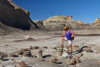
Word of another free BLM campground leads us to the Angel Peak Scenic Area, just south of Bloomfield and about two hours northwest of Albuquerque.  It's a beautiful spot about 6 miles from the highway above a series of canyons which are full of oil and gas wells, which are very popular in this corner of New Mexico.  There are only a couple of short hiking trails here, but the best part of this stay is the people we meet.

Our next-door neighbours are Mike and Melissa, a great couple whom I wish we are able to spend more time with (and I'm not saying that because they might read this blog!)  Mike is originally from Georgia, and Melissa from Florida; they married only about one year ago and have been traveling in their trailer as "full-timers" with their two dogs, Bump and Shine, since then.  Sadly, they leave after we're here only a couple of days.

Across the road is Rick, many years our senior and from Pennsylvania.  A typical hippie (seriously - he's had two hip operations), he's a hoot even when he's sober.  His dog Sadie is a bit of an attention-whore, jumping into the lap of anyone who'll pet her.  What's amazing is that Rick lives in a tent!  For two years now!  At the age of 67!  More power to him.

Two young Japanese tourists also stop by for a night.  Meeka (not sure of the spelling of her name) and Mayumi are such sweet girls and are in awe at the spaciousness of our trailer.  Their home in Japan is smaller, they say.  The come to tour a part of the U.S. each year, but unfortunately this year have been forced to re-route their plans due to the closure of the national parks thanks to the government shutdown.  That's how they ended up here.  Mayumi is a healer and Meeka is a psychic - for real!  Mayumi says that Meeka's brain is broken!  These girls are a scream.

Last was Scott, a very opinionated Texan who had a lot to say about politics, economics, immigrants - well, you name it!  He must have a really good heart too - he travels with three dogs, one of which has no front legs and hops around.  She was born that way and Scott took her in when no one else wanted her.


The view from our back window, overlooking Angel Peak and the canyon below. We are literally perched on the edge of the clay cliffs.
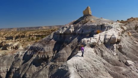
From our hike along the rim - it's a narrow trail at the peak of this long series of badlands with sandstone peaks.
The gray ridge in the foreground is the one we hiked - not entirely easy, but challenging and requires nerves of steel in places.
Mike and Melissa - funny story about that bullet hole - and it's real, not one of those decals some wimpy Americans have! Years ago, back home in Georgia, Mike discovered someone trying to steal his stereo out of his truck, as well as trying to steal his truck! So, from the safety of his front porch, he warned the thief "I have a pistol and I'm not afraid to use it!" but the thief was not too impressed. As Mike took aim, meaning to shoot the ground, the thief started to run, but Mike "missed" and accidentally shot his own truck, inches from the thief's head! Only in America. The thief got away.
Mike, Melissa, Rick, me and Brad having a fire.
Rick, Mayumi, me, Meeka and Brad.

Saturday, October 5, 2013

Bisti Badlands, NM

About 30 miles south of Farmington, New Mexico in the northwest corner lie the Bisti (BIS-tie) Badlands, part of the Bisti/De-Na-Zin Wilderness managed by the BLM and bordered by Navajo land.  After about a one-mile hike from the Bisti Wilderness parking lot, we find strange hoodoos and caprock sitting atop rutted clay mounds as well as abundant petrified trees in various stages of decay.  There are no specific trails, so we follow one interesting hoodoo to the next, being careful to keep an eye on our GPS which will guide us back.  The Bisti Wash leading back to the parking lot is dry, but - and here's what surprises us the most - there are mosquitos everywhere!  When I stop to slap Brad on the head (to kill a mosquito, of course), five more buzz towards him!  I guess the recent rains have given rise to a new generation of this annoying pest.

We don't drive the 20 miles to the De-Na-Zin Wilderness as we are low on fuel (there were no gas stations between the interstate and here!) and we still have to get the trailer to Farmington; plus we're not encouraged that we'll find much different there.  So perhaps another year.
These tiny hoodoos are miniatures of the bigger ones we see later on our hike. How do you like my new hat?
Marilyn walking through a boulder field - sandstone rocks left sitting where they landed when the clay that used to be beneath them eroded away.
A very colourful new friend for Grady - not really. This guy was brilliant green and yellow, and just finishing shedding - notice the scale on his tail.
Angel wings - some of the strange shapes of these hoodoos.
Part of a large group of hoodoos, just before sunset.
Brad surrounded by petrified wood.
This ancient tree trunk is now stone!