Every year, we try to find somewhere new to explore, and this year's trip has been no exception. Our last destination is Roosevelt Lake, about 2 hours east of Phoenix. While the lake is surrounded by lovely mountains, the elevation at the lake makes the weather comfortable in the late winter/early spring.
Bermuda Flat | |
 | There are several developed campgrounds along the west shore, however we opted for dispersed camping at Bermuda Flat near the north end of the lake. Most people camp right on the beach, but because we like to be farther away from people (and their dogs) because we like to have our cat outside, we chose a paved site above the beach. This is one of three spots like this, each equipped with a concrete pad with ramada and fire ring. The Tonto Discovery Pass is required to camp here; an annual pass is $80 and can be purchased at the Roosevelt Lake Visitor Center, or a daily pass can be purchased from a machine at the entrance. |
 | Our campsite at sunset. We had many beautiful sunsets during our stay here. The beach camping did fill up on weekends, mostly with locals who come for the fishing, but overall we had a wonderful, quiet stay. |
The Apache Trail | |
 | The Apache Trail is a winding, 43-mile paved and dirt road that connects Apache Junction in the east to Highway 188 in the west at the Theodore Roosevelt Dam. It was originally constructed in 1904 to provide access for the construction of the dam at Highway 188. It's now a very popular tourist and outdoor enthusiast destination. This is looking east at the Highway 188 bridge across the outlet to the Salt River above the dam, which is behind me. |
 | Looking down (east) the Salt River. Numerous coves dot the drive, including a couple of small lakes and marinas - Apache Lake and Canyon Lake. Water recreation is a popular activity, and there are several developed and undeveloped camping areas. |
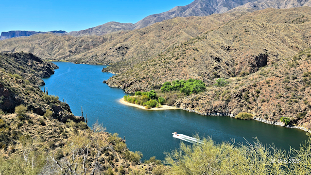
 | On a small beach called Crabtree Wash (dispersed camping okay) on Apache Lake, near the marina. What a beautiful spot to camp, have lunch, or just sit back and relax. This is as far as one can pull a trailer from Highway 188 on the Apache Trail. |
 | Driving west, the road leaves the river and heads into Fish Creek Canyon where the climb begins on the twisting, narrow road to an incredible viewpoint of the canyon below. This section of road has recently been reconstructed from washouts caused by the Woodbury Fire in June 2019. ADot has made several other improvements, and construction was still occurring when we drove through. |
 | The view looking down into the canyon from the top of Fish Creek Hill. There is a large parking lot, and porta potties. Most people seem to drive from the Phoenix area and turn back from here as signs at the top state that 4x4 is required in the upcoming 5-mile section that was previously washed out. |
 | The Superstition Mountains near the Lost Dutchman State Park in Apache Junction. At this time of year, when the sun is setting, the shadow of a cougar can be seen on the side of the mountain. We had a long drive back to camp on Roosevelt Lake, opting to take the highway back through Superior to Globe then north to Bermuda Flat, so we didn't linger to see that. |
Tonto National Monument | |
 | Along Highway 188 not far from the Windy Hill Campground is the Tonto National Monument. There are two cliff dwellings here, occupied between 1300-1450 CE by the Salado native people. The lower dwellings, pictured here, can be visiting by climbing a steep set of switchbacks from the Visitor Center. Tours of the upper dwellings are provided only by a ranger on weekends, and must be reserved. |
 | Looking up at one of the buildings from the trail. |
 | From the steep trail, the views of the deep blue waters of Roosevelt Lake are a welcome sight, contrasting spectacularly with the brown desert environment. |
Highway 60 Between Globe and the Salt River | |
 | Highway 60 from Globe to Show Low is a Scenic Byway. To be honest, I found the section from Globe to the top of the descent into Salt River Canyon rather boring. However, just before making the 2,000 foot (600 meter) descent, natives were selling Indian Fry Bread, which is a big favourite of mine, and Indian Tacos. We decided to stop and eat these rare delights instead of the salad lunches we brought. From here, the drive became much more interesting with beautiful views of the river and the canyon. In this photo, the muddy river is barely visible against the brown desert flora. |
 | A view of the river from the pedestrian bridge at the Salt River Rest Area. There is also a picnic area and washrooms. |
 | Showing the switchbacks of Highway 60 descending the 2,000 feet to the river. |
 | After crossing the bridge on the main highway, we passed the Salt River Canyon Jail Cell, now a ruin. Here is Apache Falls seen from the Lower Northside Overlook just past that. We drove only as far as Becker Butte Lookout heading north, where the highway turns away from the river before retracing our steps back to camp. |
Mogollon Rim | |
 | When we explored the area around Flagstaff in 2008 (pre-retirement), we drove through the pretty town of Payson past the Mogollon Rim. I was entranced with its towering ponderosa pines, sheer cliffs and spectacular views. And so we return for a day visit. The contrast of the green pines against the deep blue sky is colour magic. |
 | At an elevation of 7,000 feet (2,133 meters), the Rim is the place to be on a hot day. And this day was hot, still around 80F (26C) on the Rim. There's no better place to eat lunch! |
 | Brad and his typical dangling photo! Unfortunately, we were only able to drive the first 3 miles of Rim Road (aka Forest Road 300) from Highway 60 as it was still closed due to snow. I should have called the Ranger Office, although the road probably won't be open before we leave to start our drive home to Canada. |
Tonto Natural Bridge State Park | |
 | Just north of Payson, sits the surprisingly incredible Tonto Natural Bridge State Park. I use this terminology because my expectations were not high, but we absolutely loved this park. We hiked the Gowan trail to the bottom of the bridge, shown here. The bridge stands 183 feet (56m) high. |
 | Looking through the cavern under the bridge through which Pine Creek flows. It is about 400 feet long (122m) and 150 feet (46m) at its widest point. |
 | A rare sighting of a coatimundi that was climbing on the opposite wall inside the cave. These raccoon-like mammals are fairly common in Arizona, although this was only the second time we have seen one. |
 | Looking up at the ceiling of the bridge. The rock is travertine, which is laced with minerals like calcium carbonate, giving it that porous, sculptured texture. |
 | Water seeping out of the ground flows over the bridge and dances in the breeze blowing through the cave, creating a mesmerizing display. |
 | The cavern is huge, and many people were hiking and resting. The trail continues through the cavern and up Pine Creek looping back to the parking lot, although many of the rocks are treacherously slippery. We returned the way we came. Because we arrived in the early afternoon, combining it with our trip to the Mogollon Rim, we did not hike the other trails. |
Boyce Thompson Arboretum | |
 | We took a day trip back to Superior and the Boyce Thompson Arboretum. Wow! What a spectacular place, not just for desert plant lovers, but for birders too. A bronze horse statue in the Wallace Desert Garden (I think). |
 | The tiny (my baby finger size) trumpet-like flowers of tree tobacco, a toxic plant in the nightshade family. |
 | A bud of a new prickly pear pad. |
 | Such beautiful specimens of barrel cactus, agave, yucca, and prickly pear, all backdropped by Picketpost Mountain. |
 | A boojum tree, relative of the ocotillo and native to Baja California. |
 | A silver torch cactus, very hairy and very strange. |
 | Meet Mr. Big, the tallest red gum eucalyptus tree in the arboretum. It was a mere 6 feet tall when it was planted here in 1926, but now stands 117 feet (36m) high and 22 feet (6.7m) around. Eucalyptus trees are exotic to the US, originally imported from Australia. The tree (and Brad) look really thin due to the extreme wide angle lens. |
Salt River Horses | |
 | For years, I have wanted to see the wild Salt River horses, so this is my lucky year. They are usually found near Mesa, AZ, so we had to drive north on Hwy 188, then southeast on Hwy 87 to the North Bush Highway, which leads to Saguaro Lake and sort of follows the Salt River past numerous recreation areas. We saw kayakers at the Water Users Recreation Site, but no horses. |
 | We stopped at every recreation area along the Bush Highway, but had no luck finding the wild horses. But the timing was probably all wrong as it was early to mid afternoon and the horses are usually seen in the morning or evening. So we slowed down and enjoyed the sights, then did some quick shopping in Mesa, and returned to the Phon D. Sullivan Recreation Area where we finally saw a couple of these beautiful creatures in the river. A fisherman, a cormorant, and the Mazatzal Mountains complete the picture. |
 | Wading through the river, these mustangs have been here likely since the 1600s when Spanish missionaries came. Well, not these particular horses, but their ancestors. |
 | Driving back to camp, we came upon a band of about 30 horses just off the Bush Highway, not even near the river. The sun was just setting, giving me the opportunity for some lovely backlit photos. |
 | One of the horses grazing in the setting sun. Such beautiful creatures, and I am so glad we were able to see them. |
No comments:
Post a Comment