| Where are we? Highway 49; between Sacramento and Yosemite National Park; the western side of the Sierra Nevada Mountains just southwest of Lake Tahoe; between the towns of Angels Camp and Tuttletown. | |
 | We stop for a few nights on New Melones (rhymes with cajones) Lake to explore more caves and gold rush territory, although most of the gold mines in the area no longer give tours. We are near Placerville, which I think was the birthplace of the California Gold Rush. New Melones Lake is a reservoir and you can again see how low the water is - the brown grass on the far side would normally be underwater. Our campsite has a view of the bridge from the other side. |
 | A strange sight. Since lake levels are so low, and this is a reservoir, the remaining boats have to dodge the trees that once filled this valley but are now long dead. We're amazed there are any boats in this lake at all! |
| Moaning Cavern | |
 | Nearby Moaning Cavern is a cave 165 feet deep accessed by this dramatic spiral staircase. When it was built in the early 1900s, the staircase was the main attraction as it was built using the newly developed arc welding technology. For $72, you can also rappelle vertically into the chamber - nope! |
 | The chocolate waterfall inside Moaning Cavern lies directly beneath the opening in the ground, therefore rainwater dripping down causes this buildup of minerals. The colour comes from iron in the soil. |
 | A lovely example of drapery or bacon at Moaning Cavern again caused by seeping water. |
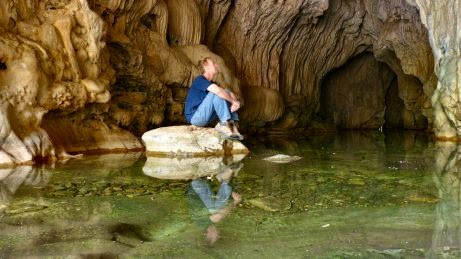
| Natural Bridges | |
 | This fantastic spot called Natural Bridges lies in a canyon near the cavern. The creek flows through a cave which we can't walk through because, not only is the water freezing, but it gets deep towards the back and our wetsuits are back at the trailer. We do cool our feet after the approximately one mile hike down, and admire the formations. The bright light on the ceiling is the reflection of the sun outside the cave - I wish you could see it dancing on the rock. |
 | Looking out of the cave at the overhang. |
 | We hike up over the top of the cave heading upriver and slide down a dry waterfall back down to the creek to find the entrance to the cave. This end is totally different with much higher ceilings. |
| Calaveras Big Trees State Park | |
 | We climb the mountains to Calaveras Big Trees State Park where giant sequoias grow (elevation around 5,000 feet, temperature about 15F cooler than at our campsite). This giant stump, the remnant of the "Discovery Tree", is a reminder of man's exploitation of nature. In 1852, five men took 22 days to cut down this tree after it was discovered by Augustus T. Dowd. Sections of the bark and part of the trunk were put on display in San Francisco, then later by ship around Cape Horn to New York. The show was unsuccessful, and the pieces were destroyed by fire while awaiting shipment to Paris. What a waste. |
 | These massive "Sierra Redwoods" can reach heights of 325 feet and a diameter of 33 feet. Sequoias are the largest living thing on earth. They are beautiful, impressive and dwarf everything around them. |
 | Brad says these trees make me look thinner. I'm not sure if that's a compliment! The one and a half mile walk through this beautiful forest fills our senses with the sweet smell of warm, dry wood. |
 | Pioneer Cabin Tree was created (in the mid-1800s?) in direct competition with Yosemite's sequoia which allowed cars to drive through it. Sadly, the carving of this arch has almost killed the tree. |
 | This is "Mother of the Forest". In the mid-1800s, she was stripped of about 60 tons of her bark up to a height of 116 feet. The bark was sent east and abroad for exhibition. Unfortunately, Mother of the Forest died without her fire and disease-protecting bark. She was skinned alive, but her corpse is a solid reminder of our past mistakes, from which mankind can hopefully learn. |
| We have two other experiences in this area for which I have no photos. We visit Columbia, an historic town now designated as a State Historic Park. Unfortunately, it is late in the day and many shops are closing, but we do walk Main Street and I find a great cup of coffee. We hope to have dinner in town, but can't find a restaurant or bar serving food - very disappointing! It really is off-season! This ain't no Tombstone. On our drive up to Big Trees, we stop in the town of Murphys where we go to a taste-testing. Yes, this is wine country, but it's not wine we taste. Instead, we test olive oils and balsamic vinegars of all flavours at Marisolio's Tasting Bar. Very yummy and great staff! We purchase several after this highly enjoyable hour+. | |
Thursday, October 23, 2014
New Melones Lake Recreation Area, CA
Lassen Volcanic National Park, CA
 | Mount Lassen, peak elevation 10,457 feet, is a volcano that erupted as recently as 1915 when ash blew 30,000 feet into the air, and lava and mud flowed down the mountainside. It changed the surrounding landscape for many miles, and is used as a laboratory for Mount St. Helens' future. |
 | Near the south entrance of the park is the Sulphur Works, where mud laced with sulphuric acid (smells like rotten eggs!) boils due to hydrothermal activity showing the volcanic activity in this area is not finished yet. |
 | We see twenty or thirty of these old babies cruising through the park today, and what a setting Lassen provides. |
 | A view of Bumpass Hell (not Bum-pass, but Bump-us) another larger area of hydrothermic activity. Named for the explorer who discovered it, there are many fumaroles (steam vents) here constantly shooting steam into the air reminding us of Yellowstone National Park, although these are not geysers. |
 | For safety, we are guided through the vents and hot pools along a boardwalk, however sadly in the 1800s when Mr. Bumpass used to provide tours, he crashed through the thin surface and his leg was severely burned in a hot pool of mud. He lost his leg due to the burns. |
 | One of the fumaroles venting. |
 | We struck gold with this free campsite in the Lassen National Forest about fifteen minutes from the park. Notice that the trees behind the beautiful stand of pines at our trailer are scorched from a fire in 2009 when this area of the rim and the valley below were devastated. Grady is enjoying the sunshine in the bottom right. |
 | In the Lassen National Forest near our campsite we find Subway Cave, a tube formed by flowing lava. It is a fairly large tube with a ceiling height ranging from 6 to 17 feet, and a total distance of 1,300 feet long, at least the portion we can walk through. It is similar to the tube caves in Lava Beds National Monument. |
Shasta - Mountain and Lake, CA
 | Mount Shasta. Yes, it's snowcapped on the north face. We have many views of this volcanic peak in Lava Beds National Monument, again during our drive back out to I-5 to get to Lassen Volcanic National Park, then again later from Lassen. |
 | A fuel stop with a view of Mount Shasta. This musical group and their dog are playing for cash to buy gas to get them to their next gig in northern California. |
 | So my mistake! We wanted to camp for a night along Lake Shasta because Brad remembers this photo he saw when we were on our honeymoon over 32 years ago of a couple laying on a sandy beach at a lake with Mount Shasta in the background. What we didn't realize (although I guess we should have) is that California is suffering a severe drought and their lakes and reservoirs are drying up. This creek is what's left of this northern arm of Lake Shasta. You can see where the lake level used to be at the tree-line. |
 | Turn 180 degrees from the previous photo, and this is our campsite. We stay the night anyway at this abandoned boat ramp and are joined by three young twenty-somethings in another camper. What's really sad though is that up in the trees all along the "lakeshore" are beautiful cabins, a couple with floating docks still visible but sitting on dry land beside the creek. I can't imagine how badly their property values have been devastated. |
Wednesday, October 15, 2014
Crater Lake National Park, OR
Let me start by saying "WOW!" We take a day-trip and drive 2 hours north of Lava Beds National Monument in northern California into southern Oregon to visit Crater Lake National Park. And you should know up front - I did NOT colour these photos on the computer.
 | This is our first view of the lake from Rim Village. The colour of the water is indescribable. It looks refreshing, but I'm sure the temperature is way below my swimming threshold! |
 | A closeup of the shallows below us. Again - the colour! |
 | Crater Lake was form by the volcano Mount Mazama whose most violent eruption was 7,700 years ago. Numerous vents emptied the mountain peak of its magma and it suddenly collapsed upon itself, creating the crater we see today. But activity continues deep beneath the surface as is evident from this cone on Wizard Island. |
 | The lake is 6 miles across at its widest point and 1,943 feet deep at its deepest. Surprisingly, the last time the lake froze over was in 1949, although the annual snowfall here averages over 43 FEET! And we think Buffalo, N.Y. gets a lot of snow! |
 | We drive the 33-mile rim road around the lake which changes in elevation from 507 feet above the lake to 1,978 feet. No streams drain into Crater Lake and none empty from it. The lake is totally self-contained, causing it to have the highest purity of water found anywhere. |
 | We take a short hike through the Pinnacles, ancient steam vents which have hardened due to the minerals in the steam that are absorbed into the pumice. Later, the pumice (lava with lots of ash and gas bubbles) surrounding the vents erode, leaving these towers. |
 | Wait a minute! How does Brad's hat stay on? |
 | Actually, Brad's not upside down, the ridge behind him is simply the reflection in the still lake water. |
Saturday, October 11, 2014
Lava Beds National Monument, CA
Lava Beds National Monument in the northeast corner of California is a large lava flow that created numerous lava tubes that are now caves. This is the largest concentration of lava tube caves in the United States.
 | Our off-interstate travel to Lava Beds National Monument takes us across Nevada and briefly up into southern Oregon. This cut on Highway 140 was steep - an 8% grade for several miles that dropped us into the valley. I (Marilyn) was lucky enough to be the driver for this leg of the journey! |
 | Brad (that tiny dot almost in the middle) inside the entrance to Skull Cave, the cave with the largest entrance and a strange line of colour which we can't explain. This cave actually had three lava tubes stacked on top of each other. Several ladder stairs take us down to the bottom level where there is an ice floor year-round. And it's freezing down there. Natives and pioneers used this cave for food storage. |
 | The ceiling inside Golden Dome. These dramatic drips remind me of meringue. Yum! |
 | Brad standing inside the entrance of Sunshine Cave, which has two collapsed sections allowing light into the cave, like a skylight. |
 | Marilyn inside Valentine Cave where lava flowed around columns throughout this cave - strange. We are constantly challenged while hiking through this cave - right or left? Doesn't matter - they both end up on the other side of the column. |
 | Tule (pron. TOO-lee) Lake was drained in the 1800s and forced into reservoirs and canals and the lakebed was turned into rich farmland, which still exists today. Note the lava flow in the foreground. This photo is taken from our hike to the top of Schonchin (pron. SKON-chin) Butte on top of which sits a fire tower used in the summer months. |
 | From Schonchin Butte, we get a fabulous view of Mount Shasta, another fourteener and a currently inactive volcano. It is one of several volcanoes in the Cascade Range - remember Mount St. Helens? It's north of here in the same chain. |
 | Marilyn at the Fleener Chimneys, a spatter cone which spit out chunks of lava that hardened into sharp globs of volcanic rock. |
 | Mammoth Crater is the source of many of the lava tubes in the park. Eruptions occurred as recently as 900 years ago, a blink in geologic time. We look down at the tops of full size trees which are growing at the bottom of this crater. |
Friday, October 10, 2014
Great Basin National Park, NV
(I am so far behind on these blogs due to weak internet signal - sorry! The following is from last week.)
Great Basin National Park lies on the eastern border of Nevada barely a few miles from Utah. The "Great Basin" is really an area between northeastern California and northwestern Utah (stretching clear across northern Nevada) where the land is being stretched geologically. The Cascade Mountain range to the west is rising due to the collision with the Pacific Plate, creating this basin behind it. We camp in Snake Valley (on the Utah side), a dry desert surrounded by mountains. But first a little excursion ...
Great Basin National Park lies on the eastern border of Nevada barely a few miles from Utah. The "Great Basin" is really an area between northeastern California and northwestern Utah (stretching clear across northern Nevada) where the land is being stretched geologically. The Cascade Mountain range to the west is rising due to the collision with the Pacific Plate, creating this basin behind it. We camp in Snake Valley (on the Utah side), a dry desert surrounded by mountains. But first a little excursion ...
 | Before getting to the national park, we spend a couple of days in Utah camped along Sevier Lake, which is usually a dry, lake bed, but because of the recent rains there is lots of water. We drive the Notch Peak Scenic Loop which provides beautiful views of the valley. Notch Peak itself is over 9,700 and is one of the highest, vertical cliff walls in North America at 4,450 feet. It is billed as Utah's El Capitan (in Yosemite National Park). This is not Notch Peak itself, but is the cliff wall along the drive north of the peak. |
 | Brad found a "new ride". I wonder how long this vehicle has been here? It's obviously been the subject of much target practice. |
 | The view from halfway around the scenic drive loop. These meadows are golden with dry grasses. Sevier Lake is in the distance, but you might not be able to see it in this small photo. |
 | For non-paved roads, these are the best we've ever been on. In fact, Brad easily travels between 50 and 60 mph over the hard-packed gravel surface, until we come across the "Open Range Cattle" with one of the calves actually lying on the road. We scare him as we approach, and then he and his two friends watch us closely while they cross the road to their moms. Aww, aren't they cute? |
 | Great Basin National Park is Nevada's only National Park. We hike the Bristlecone Pine trail, as well as part of the Glacier trail and the Alpine Lakes Loop trail. Parts of the Bristlecone Pine trail are covered in snow from the recent precipitation - where we had rain, they had snow at this elevation (7,000 to 13,000 feet). However, today is warm enough to hike in a t-shirt! Love that desert weather. |
 | A bristlecone pine - its needles hug the branch like a bottle brush. These trees can live for 5,000 years - they are the oldest living thing on the planet. They can stand for another 2,000 years in this arid environment where decay happens so slowly. Their twisted limbs create a haunted appearance that makes for interesting photos. |
 | Brad on the Glacier trail. This bowl at the top of Wheeler Peak (elev. 13,063 feet) was created by a glacier, although only a little of it is left now. Brad is standing in front of the moraine left by the receding ice, and the sun helps us capture a great pic. I did not colour in the pink on the computer - that's how the photo came out! |
 | Marilyn relaxing at Teresa Lake during the hike. This seems to be glacial melt as the water is that beautiful aqua green/blue colour. |
 | Grady enjoying the sand at an ATV area where we spend an overnighter between Winnemucca, Nevada and our next stop in northern California. |
Subscribe to:
Posts (Atom)