Showing posts with label Mining Towns. Show all posts

Friday, November 15, 2013

Mining Towns of Mina, Tonopah and Gold Point, NV

Obviously, we make it to town to buy fuel.  We are not stuck somewhere in the desert!

Between Reno and Las Vegas on lonely Highway 95 are numerous small mining towns, some still prospering, others are ghost towns.  We visit three towns - Mina, Tonopah (pron. TO-no-pah) and Gold Point.  In the early 1900s, Nevada was a boom state with gold and silver being the most mined ores.  The mountains are full of abandoned mines and ghost towns.  And along Highway 95 we pass the Playmate Ranch (renamed Wild Kat Ranch) outside of Mina and the Shady Lady Ranch north of Beatty.  They are advertised along the road and offer massages, showers, beer and women.  Not something we see every day.

Mina should be a ghost town, but isn't. There are 200 residents with only about 12 of working age. There is a store which sells fuel, beer and ice cream - all of the essentials. There is also a world-class burger stand run by two hilarious women, the owner aged 67 and her friend who is 83! These two argue like a married couple. It is call Socorro's - the owner's name - and the burgers and shakes are fantastic! And they'd better be - two burgers, two shakes and one order of onion rings cost over $30! We always see truckers at the stand, a clear indication of where to eat.
A small herd of wild burros we scare as we drive around a corner in Douglas Canyon behind Mina. I know they look like horses, but they have squarer faces and long ears.
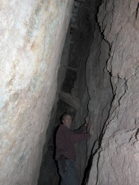
A old mining building in Douglas Canyon. Probably this building was where the rock was sorted and/or crushed to extract the ore.
In the center of Mina, only one of the many abandoned buildings. The resident dies and the building just sits to rot.
Tonopah is a fairly big town with a full grocery store, about half a dozen gas stations and other stores, but the town jewel is the Mizpah Hotel which is home to at least one ghost, the Lady in Red (a "female companion of miners") who was murdered on the fifth floor by her lover. A large cemetery is filled with pioneers and miners from the early 1900s - many from a 1902 lung "plague" and 17 from the Belmont Mine fire of 1911. There are also two excellent museums: The Central Nevada Mining Museum which showcases a lot of pioneer history of the area as well as a large collection of original mine equipment, and the Tonopah Mining Park where the three original mines which started the town have been preserved.
The headframe and hoist building of the Mizpah Mine at the Tonopah Mining Park. Originally Belle Butler's mine, and the richest of the three original mines she and her husband Jim founded, it was taken over by a large corporation by 1908 when this metal headframe was built.
The old Tonopah Cemetery. So many sad stories besides the deaths from the "Tonopah Plague" of 1902 and the mine fire of 1911; like the 33-year old woman from B.C. who died of a morphine overdose, the 11-year old boy who died of a gun shot wound, a young man who died in a mine explosion, and a Sheriff who was "shot to death".
Marilyn outside the Mizpah Hotel in Tonopah. Built in 1908, it has been renovated a couple of times, most recently by the Clines of California who spent $2 million in the renovation in 2011. The restoration is a labour of love, and it shows.
After lunch at the Mizpah Hotel, Marilyn sitting in the lobby. These sofas are the originals, painstakingly cleaned and reupholstered.
Mizpah is from Genesis, Chapter 31, verse 49 and has two interpretations.  1 - may God watch over me and thee; 2 - if you cross the line to harm me or my family, may God deal with you.
The beautiful windows of the Mizpah Hotel. The glass is purple, which in the early 1900s was a mistake when the mineral manganese was added to the glass-making process and it turned purple in the sunlight because of ultraviolet rays. There are at least half a dozen of these windows around the front and side of the hotel.
Gold Point is considered a ghost town although there are still 27 residents. Many of the original mining buildings are being restored by new owners, whom we unfortunately did not see.
Brad climbing to the gallows, first one we've ever seen and kind of creepy.
One of the buildings on Gold Street - "Hornsilver Townsite & Telephone Company". Hornsilver was the previous name of Gold Point.
Mitchell's Mercantile.
Believe it or not, this home is still inhabited by one of the 27 residents.

Saturday, December 18, 2010

Silver and Copper

I'm reminded of Burl Ives' Christmas song "Silver and Gold", except this excerpt is about silver and copper - mine tours.

First stop: Tombstone.  THE infamous Tombstone of the old west.  You know - the Earp brothers - Wyatt, Virgil and Morgan, and Doc Holliday.  The town was discovered by a prospector, Ed Schieffelin, who was told that the only thing he'd discover "out there" was his tombstone, so when he did discover his first silver mine, he named it Tombstone.  The motherlode of silver became so rich, the town that built up around the mines in the area later became known as Tombstone.  It is probably the best preserved living western town - people actually live here, it's not just a staged attraction like a Hollywood set.  Dubbed "The town too tough to die", it has some of the best named merchants ever - Big Nose Kate's Saloon, the Crystal Palace Saloon, the O.K. Corral (where the famous gun fight between the Earps and Clanton Gang is staged daily), the Bird Cage Theatre (with its original and beautiful cherrywood bar, it's said to be haunted and was stage to many famous people, including Sarah Bernhardt), and Boothill Cemetery.


Marilyn at the bar of the Bird Cage Theatre in Tombstone
We tour the Good Enough Silver Mine which opened in 1878.  The labour at that time was all manual, of course - a chisel and hammer.  But the silver ore was rich.  The ore had to be hauled about 10 miles to the nearest river for processing by horse and wagon, and by the 1930s the profit was no longer there so the mine was closed.  We also walk around the town for a couple of hours and have lunch at the Crystal Palace.  The history here is amazing.  Many of the buildings are original, like the Bird Cage Theatre and the Longhorn Saloon, or parts of them are; others are reconstructed.  The town has seen many fires - in 1881 and 1882 - which have destroyed many parts of the town; a fire destroyed the Six Gun City Wild West Show building just last week (arson is suspected).  The town IS a bit of a tourist trap and everything is expensive, but the history is interesting and all of the merchants are dressed in late 1800s garb.  It's interesting to talk to them, just the same.  They all know the history and are all willing to talk your ear off.


Miners working by candlelight in the Queen Mine
Next stop: Bisbee, a small town about 20 miles south of Tombstone, but not nearly so famous.  Bisbee is a beautiful town with Victorian style homes built on the sides of the mountain and shops in the valley, and in view of the tailings of the Copper Queen Mine.  The highway splits the tailings in half with the Lavendar Pit (this is an open pit mine and it is so named after one of the executives of the original owners) on the west side.

Brad working the Queen Mine
Brad and I suit up in yellow slickers, hardhats and flashlights, and board the electric train for an underground Queen Mine Tour with a retired miner.  We get our own personal tour since no one else shows up for the noon tour.  There are approximately 2,300 miles of tunnels under the town of Bisbee, but we will travel only 1,500 feet into one shaft.  The mine operated from 1887 to 1943, producing 8 billion pounds of copper, plus gold, silver, lead, zinc and turquoise.  It was this wealth that led it to being named the "Queen of the Copper Camps".  Our tour guide shows us how the miners drilled during the different eras, progressing from manual chisels and hammers to pneumatic drills.  We can also see where they drilled and blasted the rock with dynamite, finding the veins of copper by identifying the different minerals.  Turquoise, azurite and malachite are typically found where there is copper sulfate.  It's hard for us to believe that these three beautiful minerals were waste rock in those days.  Many of the workers took chunks of them home to make jewelry or other trinkets, or even stone fireplaces and walls.  Today, Bisbee turquoise sells for $2,000 per pound!  Today, the minerals are NOT waste rock.

Museum mineral sample from mine cave
We also visit the Mine Museum in Historic Bisbee, which is affiliated with the Smithsonian Institute.  It is extremely well done with great exhibits showing not only mining life, but life in general.  It also talks about a strange event in 1917 which the local historian, a 90-year old frisky gentleman who fell down a 3 foot ledge and hurt his leg the previous year while hiking (!!!), recounts to us even though a video has already described it to us.  At the time, the First World War was in full force.  Bisbee was the largest producer of copper, and the copper was used to produce shells for ammunition.  In 1917, the mine workers went on strike, their union having somehow been infiltrated by some Germans (this part was unclear).  The miners were mostly immigrants from Britain, Europe, and Mexico.  The Governor deputized 130 citizens and gave them lists of names to round up - in all about 90 were causing trouble, but about 1,800 were actually put on trains and DEPORTED to Mexico, even though most of them weren't Mexicans.  And they were told that the border would be watched and they were not to return; they didn't.  Their families had to join them where they were.  How awful!  The other workers returned to work and copper production continued.  The Governor was not re-elected (it was an election year).

Upstairs in the museum is a mineral display that knocks our socks off!  The azurite, malachite, gypsum, and other mineral crystals that I can't pronounce or recall the names of here are spectacular.  And they are all from the Bisbee mines where workers broke through into caves full of these beautiful mineral formations.  The specimens are said to be worth tens of thousands of dollars each.  It is said that if one area contains 200 different mineral species, then it is rare and an extremely rich find.  There are some 300 different mineral species here in Bisbee!  If you are a geologist (Dolores and Michel), then you must come here!

As we leave our RV Park in the morning (Turquoise Valley - a golf club/RV park owned by a Canadian, no less!), we notice a sign we hadn't noticed before.  The sign tells us our highway is to the left and Mexico is to the right.  How far? we wonder. I look to the right and WOW!  The border fence is right there!  A few hundred yards up the road!  Well, that does explain the number of Border Patrol vehicles we have seen in the area.  I check the map and notice that the town we are staying in, Naco (rhymes with taco), is indeed right on the border and there is a sister town called Naco on the Mexico side.  There is a huge mountain that we've been enjoying the view of too, which must be in Mexico too, we realize.  Huh!  Who knew?

Saturday, December 11, 2010

Ghost Towns and Mines

Brad is in his glory. Our hike to the Mogollon Ghost Town and Little Fanny Mine is for most of you who have had the rock hounding or ghost town bug.  We are in Gila National Forest in southwest New Mexico.  This place is rich in mining history and how settlers and those seeking fortune conflicted with and the Apache natives.  This place is like Bancroft in northern Ontario:  it is riddled with hundreds of small old mines and, although the government is imploding mines for liability reasons and looters continue to destroy properties in ghost towns, we come about an amazing ghost town and mine.  The mine is called The Little Fanny Mine and it is located in the old town of Mogollon (Muggy-own apparently, not Muggy-yon if you read the last blog).  The mine produced gold and silver in the early 1900's.  Miners were frequently killed by the Apaches as they were lured into the mountains for gold and silver.  After many years the military eventually set up forts to protect the miners.

Tailings of the Little Fanny Mine
Little Fanny Mine
It is a very steep narrow climb of about 2,000 feet up the mountain to Mogollon.  At a scenic trail lookout, we meet another couple from Tennessee, Jerry and Janice (J&J), who are also rock hounds and we make friends instantly as we all work on finding the ghost town and mine.  First we head up to the old cemetery where we see crosses made of wood and sticks like we see in the western Hollywood movies.  Many miners died within 3 years due to breathing the quartz dust created from their jack-hammers.  Other plots are entire families who all died within the same week likely due to the Spanish Influenza which was rampant during that period (August to November of 1918).  Not too many people lived past the age of 45.

Mogollon Ghost Town
Little Fanny Mine
We then find the ghost town consisting of about 20 cabins, some fallen over, others still standing and in decent shape.  We find old newspapers and magazines between the planks of cabin walls used as insulation (it's always below freezing here at night at 5,000 feet this time of year and days are a nice 60F).  Over 200 people worked the mine around 1900.  We then find the mine.  It is amazingly big.  It takes about 15 to 20 seconds for our tossed rocks to hit the bottom of some vertical mines shafts.  There were many empty barrels of cyanide which was used to leach the gold from the ground up rock.  We then come to the massive processed white quartz tailings which had been crushed to a powder but resolidified with rains over the years.  We could truly feel the hardships of life back then with the threat of Indian attacks, unsafe mining practices, diseases and cold.

The main attraction in this area is the Whitewater Canyon Catwalk.  Originally built in the late 1800s for a mining operation to bring gold, silver and copper down the canyon, the original wooden catwalk has been replaced by a metal one which is used today by tourists.  The canyon is narrow and the walk is lovely.  It is only one mile each way and easy going along the creek.  Although it is the most advertised attraction for this area, our hike the following day would prove to be the highlight of this part of our stay.

Brad in Mineral Creek Canyon
This is the hike that we were referred to a few days back from a volunteer Ranger at The Cliff Dwellings.  Although we know we are about to hike through a beautiful canyon, the Little Fanny Mine was unbeatable.  It just so happens that this hike becomes the scariest.  As we head to the trail by truck the road is so bumpy that it shakes the front plastic bumper partly off the truck.  We have no choice but to return to our campsite to repair it and we head off again.  The problem is that we lost valuable daylight!  Not thinking of it, we start hiking.  We were told that the mine is 2.7 miles and we set our GPS to track our distance.  Surprisingly, the canyon becomes one of the most beautiful canyons that we have hiked.  It is very tall, perhaps 300 to 400 feet hight, and it gets very narrow.  We can't understand how anyone can escape this canyon from the flash floods of Summer.  It is very difficult to photograph since the one side of the canyon is in sunlight and the other side is not, so photos cannot pick up the intense colours of green and orange.  The beauty of the canyon slowly becomes our enemy as we stop frequently to admire the colours and rock formations.  We are losing, again, valuable daylight.

Brad in the mine at Mineral Creek
After hiking 2 hours we can't understand why we have not yet spotted a large boiler that marks the location of the mine.  We check the GPS.  it shows a distance of 1.2 miles.  We can't believe that's all we've hiked.  Brad had remembered one of the two most important things to bring on the hike; his watch (the other is the flashlight).  The sun sets at 5pm and it's 2:30.  In this deep canyon, you cannot predict the time and therefore when it will be too dark to hike out.  Even with a flashlight the canyon would be challanging with the many river crossings required here.  Brad suggests we turn back and try again tomorrow but I suggest to carry on to see if the mine is not far away and there is some mistake with the distance noted on the GPS.  We pick up our hiking speed and within 20 minutes we find the boiler and the mine at 2.06 miles, not 2.7 miles.  We climb the mine tailings to find the shafts.  We soon find them and the supporting timbers are surprisingly in good shape.  The walls of the mine are green and turquoise (copper oxide) and bright blue (Azurite).  We also see lots of pyrite.  Brad writes "I am usually stupidly brave in these mines but while crawling on my hands and knees on a two foot wide path with a wall on one side of me and a "bottomless" vertical mine shaft on the other side of me my heart races.  I am then past the vertical shaft and I continue on walking on large timbers with shafts below me.  My adrenaline pumps.  I finally make it to the main vertical shaft and I can't see the bottom because my powerful flashlight won't shine that far.  I keep calling back to Marilyn to let her know that I am OK.  I can't resist it; I toss a 50 lb. rock into the shaft to get an idea of it's depth.  The rock hits water below after 7 seconds that sends a huge shock wave of sound through the water and into the surrounding rock.  I instantly regret doing this as the shock wave may have been enough to collapse the shafts aroung me.  I immediately turn around and head back out, taking no more photos."

Marilyn crossing Mineral Creek
Limiting our time to only 15 minutes at the mine, we collect up our rock samples and immediately start hiking back.  We are hustling to beat the clock: it's 3:45pm.  Our calves are burning while walking fast.  The temperture starts falling fast.  Brad says "I imagine trying to sleep in the canyon where you can't see your hand in front of your face and the temperature drops from 65F to 20F.  I at least have a lighter and there is dry tree branches for a fire.  However, I'm sorry we don't have a little compact pup tent in our back pack."  We don't hesitate and study the rocks as we have to cross the creek at least 20 times.  It starts to get a little dark and we suddenly see our truck...about 10 minutes away from having to use the flashlight.  That was 70 minutes for 2 mile of rough hiking that took over 2 hours in.  As we get in the truck we are overcome with a thrillseekers' explosion of feelings.  What a rush!  Now my sisters are freaking out and I'm going to get another email chastising me about being careful!

Our last hike on this leg of our journey takes us to the San Francisco Hot Springs.  The trailhead is just off Highway 180 and the hike is 1.5 miles each way.  For the most part, this canyon is not steep like Mineral Creek.  The canyon walls on either side are gentle rolling hills covered with dry grasses and desert scrub.  We are warned that this is cougar country, and Brad has the Bear Pepper Spray - we did NOT see any cougars.  The first mile of the trail is fairly easy although a bit rocky.  The last half mile is a steep grade down into the valley where a creek is flowing.  We have to cross this creek and it is mid-thigh deep, so we have to remove our shoes, socks and pants.  It is difficult to find the pools, which are right along the edge of the creek, because they are so well hidden by the tall, dry grasses.  The pool temperatures are perfect: one pool is about body temperature; the other is about 102F to 104F.

Again, we have the hot springs all to ourselves, which makes the outing so much more special.  We enjoy a picnic and a soak before tackling the steep climb back out of the valley.  Once again, we arrive back at the truck only 10 minutes before it's fully dark, while watching another beautiful sunset of pink and orange clouds.  Another perfect day, another exciting area of New Mexico explored.