Brad is in his glory. Our hike to the Mogollon Ghost Town and Little Fanny Mine is for most of you who have had the rock hounding or ghost town bug. We are in Gila National Forest in southwest New Mexico. This place is rich in mining history and how settlers and those seeking fortune conflicted with and the Apache natives. This place is like Bancroft in northern Ontario: it is riddled with hundreds of small old mines and, although the government is imploding mines for liability reasons and looters continue to destroy properties in ghost towns, we come about an amazing ghost town and mine. The mine is called The Little Fanny Mine and it is located in the old town of Mogollon (Muggy-own apparently, not Muggy-yon if you read the last blog). The mine produced gold and silver in the early 1900's. Miners were frequently killed by the Apaches as they were lured into the mountains for gold and silver. After many years the military eventually set up forts to protect the miners.
 |
Tailings of the Little Fanny Mine
|
 |
Little Fanny Mine
|
It is a very steep narrow climb of about 2,000 feet up the mountain to Mogollon. At a scenic trail lookout, we meet another couple from Tennessee, Jerry and Janice (J&J), who are also rock hounds and we make friends instantly as we all work on finding the ghost town and mine. First we head up to the old cemetery where we see crosses made of wood and sticks like we see in the western Hollywood movies. Many miners died within 3 years due to breathing the quartz dust created from their jack-hammers. Other plots are entire families who all died within the same week likely due to the Spanish Influenza which was rampant during that period (August to November of 1918). Not too many people lived past the age of 45.
 |
Mogollon Ghost Town
|
 |
Little Fanny Mine
|
We then find the ghost town consisting of about 20 cabins, some fallen over, others still standing and in decent shape. We find old newspapers and magazines between the planks of cabin walls used as insulation (it's always below freezing here at night at 5,000 feet this time of year and days are a nice 60F). Over 200 people worked the mine around 1900. We then find the mine. It is amazingly big. It takes about 15 to 20 seconds for our tossed rocks to hit the bottom of some vertical mines shafts. There were many empty barrels of cyanide which was used to leach the gold from the ground up rock. We then come to the massive processed white quartz tailings which had been crushed to a powder but resolidified with rains over the years. We could truly feel the hardships of life back then with the threat of Indian attacks, unsafe mining practices, diseases and cold.
The main attraction in this area is the Whitewater Canyon Catwalk. Originally built in the late 1800s for a mining operation to bring gold, silver and copper down the canyon, the original wooden catwalk has been replaced by a metal one which is used today by tourists. The canyon is narrow and the walk is lovely. It is only one mile each way and easy going along the creek. Although it is the most advertised attraction for this area, our hike the following day would prove to be the highlight of this part of our stay.
 |
| Brad in Mineral Creek Canyon |
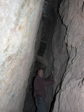
This is the hike that we were referred to a few days back from a volunteer Ranger at The Cliff Dwellings. Although we know we are about to hike through a beautiful canyon, the Little Fanny Mine was unbeatable. It just so happens that this hike becomes the scariest. As we head to the trail by truck the road is so bumpy that it shakes the front plastic bumper partly off the truck. We have no choice but to return to our campsite to repair it and we head off again. The problem is that we lost valuable daylight! Not thinking of it, we start hiking. We were told that the mine is 2.7 miles and we set our GPS to track our distance. Surprisingly, the canyon becomes one of the most beautiful canyons that we have hiked. It is very tall, perhaps 300 to 400 feet hight, and it gets very narrow. We can't understand how anyone can escape this canyon from the flash floods of Summer. It is very difficult to photograph since the one side of the canyon is in sunlight and the other side is not, so photos cannot pick up the intense colours of green and orange. The beauty of the canyon slowly becomes our enemy as we stop frequently to admire the colours and rock formations. We are losing, again, valuable daylight.
 |
| Brad in the mine at Mineral Creek |
After hiking 2 hours we can't understand why we have not yet spotted a large boiler that marks the location of the mine. We check the GPS. it shows a distance of 1.2 miles. We can't believe that's all we've hiked. Brad had remembered one of the two most important things to bring on the hike; his watch (the other is the flashlight). The sun sets at 5pm and it's 2:30. In this deep canyon, you cannot predict the time and therefore when it will be too dark to hike out. Even with a flashlight the canyon would be challanging with the many river crossings required here. Brad suggests we turn back and try again tomorrow but I suggest to carry on to see if the mine is not far away and there is some mistake with the distance noted on the GPS. We pick up our hiking speed and within 20 minutes we find the boiler and the mine at 2.06 miles, not 2.7 miles. We climb the mine tailings to find the shafts. We soon find them and the supporting timbers are surprisingly in good shape. The walls of the mine are green and turquoise (copper oxide) and bright blue (Azurite). We also see lots of pyrite. Brad writes "I am usually stupidly brave in these mines but while crawling on my hands and knees on a two foot wide path with a wall on one side of me and a "bottomless" vertical mine shaft on the other side of me my heart races. I am then past the vertical shaft and I continue on walking on large timbers with shafts below me. My adrenaline pumps. I finally make it to the main vertical shaft and I can't see the bottom because my powerful flashlight won't shine that far. I keep calling back to Marilyn to let her know that I am OK. I can't resist it; I toss a 50 lb. rock into the shaft to get an idea of it's depth. The rock hits water below after 7 seconds that sends a huge shock wave of sound through the water and into the surrounding rock. I instantly regret doing this as the shock wave may have been enough to collapse the shafts aroung me. I immediately turn around and head back out, taking no more photos."
 |
| Marilyn crossing Mineral Creek |
Limiting our time to only 15 minutes at the mine, we collect up our rock samples and immediately start hiking back. We are hustling to beat the clock: it's 3:45pm. Our calves are burning while walking fast. The temperture starts falling fast. Brad says "I imagine trying to sleep in the canyon where you can't see your hand in front of your face and the temperature drops from 65F to 20F. I at least have a lighter and there is dry tree branches for a fire. However, I'm sorry we don't have a little compact pup tent in our back pack." We don't hesitate and study the rocks as we have to cross the creek at least 20 times. It starts to get a little dark and we suddenly see our truck...about 10 minutes away from having to use the flashlight. That was 70 minutes for 2 mile of rough hiking that took over 2 hours in. As we get in the truck we are overcome with a thrillseekers' explosion of feelings. What a rush! Now my sisters are freaking out and I'm going to get another email chastising me about being careful!
Our last hike on this leg of our journey takes us to the San Francisco Hot Springs. The trailhead is just off Highway 180 and the hike is 1.5 miles each way. For the most part, this canyon is not steep like Mineral Creek. The canyon walls on either side are gentle rolling hills covered with dry grasses and desert scrub. We are warned that this is cougar country, and Brad has the Bear Pepper Spray - we did NOT see any cougars. The first mile of the trail is fairly easy although a bit rocky. The last half mile is a steep grade down into the valley where a creek is flowing. We have to cross this creek and it is mid-thigh deep, so we have to remove our shoes, socks and pants. It is difficult to find the pools, which are right along the edge of the creek, because they are so well hidden by the tall, dry grasses. The pool temperatures are perfect: one pool is about body temperature; the other is about 102F to 104F.
Again, we have the hot springs all to ourselves, which makes the outing so much more special. We enjoy a picnic and a soak before tackling the steep climb back out of the valley. Once again, we arrive back at the truck only 10 minutes before it's fully dark, while watching another beautiful sunset of pink and orange clouds. Another perfect day, another exciting area of New Mexico explored.