For a busy city, Phoenix has several lovely parks which we have never visited in our 13 years of exploring the southwest. So we headed east after Christmas instead of going straight to Yuma like we usually do. We found free camping just off Highway 74 (aka Lake Pleasant Road) on the east side of North New River Road. Lots of space as well as many other RV campers.
Cave Creek Regional Park | |
| Our first hike was at Cave Creek Regional Park on the Slate Trail, to see the Michelin Saguaro. The trail was verdant with palo verde, cholla, and other desert flora. We were told at the Visitor Center that this is one of only 3 known saguaro of this type, and no one knows why they grow this way. | |
| We then backtracked to the connecting trail that joins to the Go John Trail, and looped back to the parking lot. The Go John Trail has wonderful views overlooking the valley and outlying cities north of Phoenix. | |
| All trails are multi-use and we did see several other hikers, cyclists and horseback riders. It was a pretty hot day, even for January, although the elevation helped a bit. Even the horses were sweating! | |
White Tank Mountain Regional Park | |
| We hiked one day at White Tank Mountain Regional Park, taking the Black Rock Trail to the Waterfall Canyon Trail. As you can see, there is no waterfall now, although a small pool at the base remained. Due to the shade, the area at the "waterfall" is incredibly cool since the rocks act like a refrigerator. | |
Watson Lake in Prescott | |
| It has been 9 years since we have been to the Granite Dells, aka Watson Lake near Prescott. But this year, we have kayaks. Even though it's a one and a half hour drive north, we pack up and spend a day kayaking the lake. I'm so glad we did, as the water was so calm, great for kayaking. | |
| We both took a lot of photos here, but sometimes you just have to sit back and enjoy the scenery as you float by. | |
| A view of the lake and the granite rocks from the parking lot at the top of Watson Lake Park Road. The snow-capped San Francisco Mountains and Humphreys Peak above Flagstaff can be seen in the distance. | |
Agua Fria National Monument | |
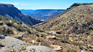
| We hiked a short, easy trail from I-17 (with very dangerous parking right on the side of the interstate!) to the abandoned Richinbar Mine which sits above Agua Fria Canyon within the Agua Fria National Monument. When you get to the canyon, the trail turns right or left. Follow up to the left and look on the backside of the rocks at the small peak to see petroglyphs. The trail to the right goes to the mine. | |
| Remnants possibly of the head frame at the Richinbar Mine site. Brad loves abandoned mines, although there wasn't much to see here. Honestly, the terrain along the trail is very open and not very interesting, although the view into the canyon is nice, and came as a surprise. I think we might have enjoyed the hike at Badger Springs, just a few more miles north on I-17, where there are also facilities and proper exit/on ramps. | |


