Showing posts with label Nevada. Show all posts

Sunday, November 10, 2024

Lake Tahoe in Nevada and California, October 2024

Our first destination this season is at Lake Tahoe, which borders California and Nevada. Tahoe is famous for its clear waters, incredible scenery, and epic skiing. We stayed at Zephyr Cove RV Resort and Campground on the Nevada (east) side, just north of South Lake Tahoe. Our elevation here is about 6,000 feet (1,800 metres), so nights are cold, but days are warm and sunny. The dry air and the smell of the huge pines are a welcome reprieve from the east's humidity and crowds.

Truckee River Bike Path


Our friend Jody from Idaho joined us for the beginning of our trip. We are pictured here at an overlook on the drive up to Tahoe City on the west side of the lake, where the Truckee River Bike Trail begins. Jody is holding her little Yorkie/Shih Tzu mix, Jazz who is only 6 months old. Behind us is beautiful Emerald Bay and Fannette Island, on which there is a stone tea house built by Lora Josephine Knight in the late 1920s. Her castle, Vikingsholm, is on the shore of the Bay (not visible from this overlook) in what is now Emerald Bay State Park. Unfortunately, it is closed for the season.

A gated bridge along the Truckee River. While the setting is peaceful and serene, Highway 89 follows the river, and hence the bike trail, so we always have some traffic noise. Oh well, it is beautiful anyway.

We followed the 6 mile (10 km) trail to Olympic Valley Park. This sign commemorates the 1960 Winter Olympics, which were held here.

Virginia City


We planned to go to Carson City and walk the Kit Carson trail, but realized it was just a walking tour around the historic part of town, and the buildings didn't look that old. So we opted to continue on to Virginia City where there was a tour of the Chollar Mine for Brad. As with most old mines, there is a lot of old equipment to walk around as well. This is an old stamp mill. A sign on the side reads "Five Stamp Mill Crushed gold and silver ores Yield 15 tons per day 1860 to 1920".

The church behind me on the right is Saint Mary in the Mountains. There is another church behind it to the left called St. Paul the Prospector Episcopal Church.

This town was fun to walk around, with many little shops, bars, restaurants and cafes. The Tahoe House Hotel was built in 1859. Samuel Clemens stayed here before he became Mark Twain. Rooms are still available to rent today.

Kayaking at Sand Harbor


Brad overlooking the lake at Sand Harbor Beach. The water is so clear, in fact, it is 99.994% pure. Lake Tahoe is the second largest alpine lake in North America with 39 trillion gallons of water; the second deepest lake in the United States (averages 1,000 feet or 300 meters); and it never freezes over.

The most exciting thing we wanted to do on Lake Tahoe was kayak in one of the glass bottom boats. There are several companies and tours to choose from. We chose Clearly Tahoe and the Bonsai Rock tour. Our guide was excellent, in fact, he took this photo of Brad and me.


Another view from the beach at Sand Harbor looking northwest. It would have been prettier with snow on the mountains.


Friday, December 30, 2016

Lake Mead and Valley of Fire State Park

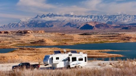
Just outside of Las Vegas is one of our favourite areas. The Lake Mead National Recreation Area is a beautiful spot to camp over the lake, and Valley of Fire State Park is a spectacular area of bright red/orange sandstone formations with great hiking.
Hanging out at Lake Mead with new friends

We meet a new friend, Jody, while hiking in Valley of Fire State Park, and she comes to join us camping at Lake Mead for a few nights. She and I quickly become best buddies, laughing and carrying on. Poor Brad. She also has the cutest little dog, BooBoo, whom Grady attacks. Poor BooBoo.
A night at the campfire with Jody and Grace, whom we first met last year outside of St. George. Strangley, we run into Grace and her hubby Greg camped here at Stewart's Point; in fact, they are in our favourite spot. Such a strange coincidence.
Grace takes Brad out kayaking on the lake on a very calm day.
Carroll Shelby Museum in Las Vegas
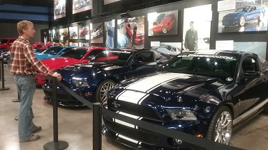
Brad is in heaven, surrounded by so many Shelbies and Mustangs made into Shelbies. From the old Cobras to the new Shelbies, including a Shelby 1000 pictured here (that's 1,000 horsepower and it's barely street legal!), there's a wide assortment of everything ever touched by Carroll Shelby.
Inside the shop. Shelby is not a car manufacturer. They only modify cars. The old style Cobra seen here is a brand new car, and neither of the two vehicles in the foreground have an engine in them - yet. This tour was very interesting and worthwhile, and best of all it's free. I highly recommend it to anyone who loves cars in general and Shelbies in particular, and tires of Las Vegas strip.
Hiking
On the Arches Trail in Valley of Fire State Park, a group of horsemen/women ride past us. Smart - the sand in the wash on this hike is deep and going is tough. Even the horses are sweating and it's only about 55F today.
A hike into the Bowl of Fire in Lake Mead National Recreation Area. It's a stunning outcrop of very red/orange rock against the brown Muddy Mountains.
We hike from the main road in Valley of Fire State Park with Jody through Wash #3. This area makes us all think about Orange Cremesicles because the rocks are striped white and bright orange. Sadly, no ice cream can be found within 20 miles.
Brad and I have hiked this wash before and we know there is an area of rock with beautiful, colourful striping. We're very happy that we actually are able to find it, after a 3 year absence. This is a small section of rock wall about 3-4 feet across.
Another abstract section of rock wall about 1-2 feet wide. Reminds me of an alien spaceship looking for a landing site.
Last one - these are just so cool. This one is probably only about 1 foot wide.

Wednesday, January 7, 2015

Lake Mead National Recreation Area, NV

Last year we spent an unbelievable month at Lake Mead NRA (home of the Hoover Dam just outside of Las Vegas) and decide this year to return as a stop-over before heading into southern Arizona. While we spent Christmas just a short distance northeast at Whitney Pockets, (30 miles as the crow flies, but about 90 on roads) we spend New Year's at Stewart's Point on Lake Mead, a favourite (free) camp spot of ours.

We are met with this strange scene as we are driving along Northshore Boulevard just inside the park boundary. Your guess is as good as mine, and I don't find anything in local online news sources about this event. Obviously an emergency landing; not your everyday sight. We've had some strange "in the right place at the right time" events on this trip.

New Year's Day. A "storm" sweeps through the southwest bringing strong winds, chilling temperatures (for here around 0C or 32F) and snow above 2,000 feet. Thankfully, the dry air here allows us to bear the cold easily, and we are rewarded the morning after with this spectacular view of the Virgin Mountains to the northeast.

Unlike last year when we were here, this year we don't go out to do any hiking, even in nearby favourite Valley of Fire State Park. We spend the days walking around Stewart's Point with Grady, collecting garbage, and a few evenings by the campfire enjoying the moon rising in the glow of the sunset across the lake.

Not all of our days here are cloudless, and that's a good thing. Here Brad captures one of several brilliant sunsets.
We do engage in some unusual activity for us during our week at Lake Mead. Outlet mall shopping! Brad's never been to one, and neither of us are shoppers, but we need new running shoes and hiking boots, so we head to the mall AFTER the holiday crowds disperse. It's a fun day and, being a one hour drive from our camp spot, we combine it with some grocery shopping, dinner and a movie (Interstellar - not so stellar!). As we leave early in the morning, we see a bighorn sheep beside the road and the next morning two loons are swimming near "our" beach. Their call reminds us of Ontario's northern lakes - the call of home and autumns spent with beloved friends.
Update on second week at Lake Mead

The bald eagle we spot one morning. The photo is blurry because it's such telephoto zoom without a tripod, but he's beautiful just the same.

Another journey to nearby Valley of Fire State Park, one of our favourite southwest destinations. These are "The Cabins" built by the Civilian Conservation Corps in the 1930s and used as shelters by campers in the park in the 1930s and 1940s. The CCC was formed by the government to create employment during the Great Depression and they are responsible for many structures including park buildings and dams during this period.

During a hike behind The Cabins, we scare up a herd of bighorn sheep. These two get separated from their buddies, but reunite after we pass.

Monday, December 29, 2014

Whitney Pocket, NV

Where? About one hour north of Las Vegas on I-15 is the city of Mesquite in the Virgin Valley. Head east about 30 miles on the rough but paved Gold Butte Road to Whitney Pocket, an area of orange, pink and yellow rocky outcroppings in the desert nestled beneath the Virgin Mountains.

Whitney Pocket

Our campsite among the colourful rocks and joshua trees. There are several "dispersed" campsites in this area and other campers (mostly ATVers) come and go. We spend Christmas here.

Grady loves it here, climbing the rock faces and rolling around on the flat, rough sections. His climbing skills are greatly improved following our week here.

Many different lichens grow on the rocks, including moss which you don't expect to see in the desert. It's very wet here for some reason, perhaps they've had a lot of rain recently.

We spend several days just scrambling around on the various rocky outcroppings. This is a typical formation, similar to the "beehives" found in nearby Valley of Fire State Park.
Little Finland

About 20 miles from Whitney Pocket, down the very rough Gold Butte Road and sandy Mud Wash is an area known as Little Finland where unusually eroded sandstone shapes haunt the silent desert. I love this photo because it creates a wonderful illusion.

Much of the orange sandstone is streaked with white, probably gypsum deposits.

One of the "goblin" creatures overlooking the valley.

Another unusual, more elaborate shape. This block is about five feet high and eight feet wide.

Part of the ridge, with the eroded shapes towering into the clear, blue sky.

Looking south down the length of the half-mile ridge. The palm trees at the base of the cliffs look as if they've been planted here specifically to add a splash of green to the otherwise red/orange landscape. You might have trouble seeing him, but Brad is the blue dot on the cliff edge between the nearest two palm trees.
Gold Butte Road

The old mining location of Gold Butte, which was active only from 1905 to 1910 when gold was found in the area. There's really not much left here except a few concrete pads and rusted sluicing equipment. Although this photo is kind of boring, I include it because this area is so different from nearby locations.

Between Little Finland and Gold Butte Road is a short but interesting slot canyon known as the Seven Keyholes.

Friday, October 10, 2014

Great Basin National Park, NV

(I am so far behind on these blogs due to weak internet signal - sorry!  The following is from last week.)

Great Basin National Park lies on the eastern border of Nevada barely a few miles from Utah. The "Great Basin" is really an area between northeastern California and northwestern Utah (stretching clear across northern Nevada) where the land is being stretched geologically. The Cascade Mountain range to the west is rising due to the collision with the Pacific Plate, creating this basin behind it. We camp in Snake Valley (on the Utah side), a dry desert surrounded by mountains. But first a little excursion ...
Before getting to the national park, we spend a couple of days in Utah camped along Sevier Lake, which is usually a dry, lake bed, but because of the recent rains there is lots of water. We drive the Notch Peak Scenic Loop which provides beautiful views of the valley. Notch Peak itself is over 9,700 and is one of the highest, vertical cliff walls in North America at 4,450 feet. It is billed as Utah's El Capitan (in Yosemite National Park). This is not Notch Peak itself, but is the cliff wall along the drive north of the peak.
Brad found a "new ride". I wonder how long this vehicle has been here?  It's obviously been the subject of much target practice.
The view from halfway around the scenic drive loop.  These meadows are golden with dry grasses.  Sevier Lake is in the distance, but you might not be able to see it in this small photo.
For non-paved roads, these are the best we've ever been on. In fact, Brad easily travels between 50 and 60 mph over the hard-packed gravel surface, until we come across the "Open Range Cattle" with one of the calves actually lying on the road. We scare him as we approach, and then he and his two friends watch us closely while they cross the road to their moms. Aww, aren't they cute?
Great Basin National Park is Nevada's only National Park. We hike the Bristlecone Pine trail, as well as part of the Glacier trail and the Alpine Lakes Loop trail. Parts of the Bristlecone Pine trail are covered in snow from the recent precipitation - where we had rain, they had snow at this elevation (7,000 to 13,000 feet). However, today is warm enough to hike in a t-shirt! Love that desert weather.
A bristlecone pine - its needles hug the branch like a bottle brush. These trees can live for 5,000 years - they are the oldest living thing on the planet. They can stand for another 2,000 years in this arid environment where decay happens so slowly. Their twisted limbs create a haunted appearance that makes for interesting photos.
Brad on the Glacier trail. This bowl at the top of Wheeler Peak (elev. 13,063 feet) was created by a glacier, although only a little of it is left now. Brad is standing in front of the moraine left by the receding ice, and the sun helps us capture a great pic. I did not colour in the pink on the computer - that's how the photo came out!
Marilyn relaxing at Teresa Lake during the hike. This seems to be glacial melt as the water is that beautiful aqua green/blue colour.
Grady enjoying the sand at an ATV area where we spend an overnighter between Winnemucca, Nevada and our next stop in northern California.

Friday, December 27, 2013

Valley of Fire State Park, NV

Valley of Fire State Park is only a couple of miles from the north entrance of the Lake Mead National Recreation Area.  We took Brandon to this park when he was here at the end of October, but we return because it's such an amazingly beautiful place to explore and has since become one of our top favourite all-time southwest destinations.

A candy cane dryfall. A little off the White Dome trail, we climbed some rocks and found this rainbow of rock! What the heck?
Near the end of the White Dome trail, down in a canyon that ends in a very steep, long crevice. This photo should freak out my sisters!
An area I'll call Painted Rock (or perhaps Rainbow Rock), but which has no specific trail or designation. Accessed from Parking Lot 3, hiking about 1/4 mile down towards Wash 5. This photo taken by climbing up the ridge adjacent to Painted Rock. Looks like someone spilled some paint!
A different side view of Painted Rock.
Brad on Painted Rock. It's not a huge area, but big enough to be breathtaking.
More candy stripe rocks in Wash #3.
A Painted Lady (Vanessa cardui) who joined us for lunch.
Erosion at work.
Brad taking a photo along a strangely eroded "dragon's backbone".
How does sand layer in such colours and become stone? Valley of Fire is filled with such scenes.