Showing posts with label New Mexico. Show all posts

Wednesday, May 15, 2024

New Mexico from Las Cruces to Capitan to Socorro, Fall 2017

Blog Resurrection ...

I haven't updated this Blog in seven years, and we have been to so many NEW places in these past years that it seems prudent to do so now. So let's continue from Texas.

We have spent a fair bit of time in New Mexico on previous trips, visiting White Sands National Monument near Alamagordo, and Valley of Fires Recreation Area near Carrizozo. In November and December 2017, we visited a few new places.


Our friends were campground hosting at Aguirre Springs Recreation Area Campground, and invited us for Thanksgiving. There are several nice hiking opportunities in the park and on the west side of the Organ Mountains at Dripping Springs Natural Area. Photo'd here is Brad on the Pine Tree Trail. I love the jagged peaks of the Organ Mountains.


Just south of Socorro is the Bosque del Apache National Wildlife Refuge, a bird migration stopover. We saw numerous species of ducks, sandhill cranes (pictured), bald eagles, and snow geese (tens of thousands flew overhead while we were there). What a spectacle! A road allows visitors to drive the perimeter of the refuge.

The Quebradas Scenic Byway is an unpaved 24-mile road near Socorro. It passes through colorful geology and benches above the Rio Grande. We really enjoyed this drive.

The Three Rivers Petroglyph Site is just off Highway 54 between Tularosa and Carrizozo. Over 21,000 petroglyphs adorn this basalt ridge. There is a small campground and a hiking trail.

As a child of the 60s, I grew up with Smokey Bear (NOT Smokey THE Bear) encouraging us to help prevent forest fires. So when I learned that he was buried nearby in Capitan, I had to go. At 6,350 feet above sea level (1,935m), Capitan a good long climb from Carrizozo, and a lot colder once you get up there. But I'm happy to have honored this little hero with a visit.
Back story - Smokey was found as an orphaned cub clinging to a tree with burned paws after the Capitan Gap fire in 1950. He was nursed back to health, became a symbol of fire prevention and lived his life out at a zoo in Washington, D.C. before passing away in 1976. He is buried in Capitan's Smokey Bear Historic Park. "Remember, only you can prevent forest fires."

Thursday, February 23, 2017

White Sands National Monument, New Mexico

White Sands is one of our favourite places to visit. I don't know why, there aren't many trails here to hike. But, you can walk out onto the cool, white sand and go for miles. Kids sled down the dunes. I guess what we love about it is the spectacular photography and the location in the Tularosa Basin nestled between the Sacramento Mountains to the east and the San Andreas Mountains to the west, near the city of Alamagordo.


The sand dunes are fed by the winds blowing from the southwest across Lake Lucero which is a deposit of gypsum and selenite crystals. The dunes are a beautiful, white colour, but very alkaline and salty making conditions tough for animal and plant life.
Here the sand has engulfed a skunkbush sumac tree and solidified around it, forming these gypsum pedestals. The trees may continue to bloom yellow and white flowers, and red and orange berries in the spring.
A young yucca, with its elongated shadow and the sand ripples make a gorgeous shot.
The Soaptree Yuccas grow so tall. This one dwarfs me.
The gypsum sand re-crystalizing as selenite.


The next few days, and the last days, of this trip are supposed to be spent in Carlsbad, New Mexico visiting Carlsbad Caverns (again) and Sitting Bulls Falls (for the first time), but suddenly a really good four-day window opens up and we decide that, after spending the night in Carlsbad to visit with friends Grace and Greg (whom we first met in St. George in December 2015 and again accidentally met at Lake Mead in December 2016), we will drive straight home.

The 1,800-mile (2,900-km) drive home is gloriously uneventful, and we arrive home, safe and sound, to great weather and our greatly missed family. Another trip completed. I will post one more blog, outlining trip numbers - distances, costs, etc.

Wednesday, October 9, 2013

Navajo Lake State Park, NM

Since National Parks are still closed, we take a side trip a bit east of Bloomfield to Navajo Lake State Park.  The "lake" is really a reservoir created by the Navajo Dam on the San Juan River, part of the Colorado River Dam System.  It's actually a beautiful area, surrounded by golden sandstone bluffs and mesas.  There are many boats moored in the marina, most closed up for the winter already.  One of the pontoon boats at the end of one of the mooring docks is about 60 feet long with its own hot tub and deck on the dock!

We spend only one day checking out the dam (the second largest earth dam in North America) and the San Juan River which is very popular for trout fishing.  The reservoir is home to many Chinook Salmon and Northern Pike and numerous fishermen are trying their luck today.

The marina in Navajo Lake. Note, this is our first cloudy day in a while - it's a cold front coming.
Brad standing on near the road on top of the dam overlooking the spillway and the San Juan River.
This guy - possibly a gopher or bull snake, not sure which - startled me on the trail by the river. He was very non-agressive (so maybe not a bull snake) and just kept trying to hide under the bushes.
Well, this tarantula also startled me in the corner of the parking lot of one of the day-use areas near the river. That's my critter quota for the day - thank you!

Angel Peak Scenic Area, NM

Word of another free BLM campground leads us to the Angel Peak Scenic Area, just south of Bloomfield and about two hours northwest of Albuquerque.  It's a beautiful spot about 6 miles from the highway above a series of canyons which are full of oil and gas wells, which are very popular in this corner of New Mexico.  There are only a couple of short hiking trails here, but the best part of this stay is the people we meet.

Our next-door neighbours are Mike and Melissa, a great couple whom I wish we are able to spend more time with (and I'm not saying that because they might read this blog!)  Mike is originally from Georgia, and Melissa from Florida; they married only about one year ago and have been traveling in their trailer as "full-timers" with their two dogs, Bump and Shine, since then.  Sadly, they leave after we're here only a couple of days.

Across the road is Rick, many years our senior and from Pennsylvania.  A typical hippie (seriously - he's had two hip operations), he's a hoot even when he's sober.  His dog Sadie is a bit of an attention-whore, jumping into the lap of anyone who'll pet her.  What's amazing is that Rick lives in a tent!  For two years now!  At the age of 67!  More power to him.

Two young Japanese tourists also stop by for a night.  Meeka (not sure of the spelling of her name) and Mayumi are such sweet girls and are in awe at the spaciousness of our trailer.  Their home in Japan is smaller, they say.  The come to tour a part of the U.S. each year, but unfortunately this year have been forced to re-route their plans due to the closure of the national parks thanks to the government shutdown.  That's how they ended up here.  Mayumi is a healer and Meeka is a psychic - for real!  Mayumi says that Meeka's brain is broken!  These girls are a scream.

Last was Scott, a very opinionated Texan who had a lot to say about politics, economics, immigrants - well, you name it!  He must have a really good heart too - he travels with three dogs, one of which has no front legs and hops around.  She was born that way and Scott took her in when no one else wanted her.


The view from our back window, overlooking Angel Peak and the canyon below. We are literally perched on the edge of the clay cliffs.
From our hike along the rim - it's a narrow trail at the peak of this long series of badlands with sandstone peaks.
The gray ridge in the foreground is the one we hiked - not entirely easy, but challenging and requires nerves of steel in places.
Mike and Melissa - funny story about that bullet hole - and it's real, not one of those decals some wimpy Americans have! Years ago, back home in Georgia, Mike discovered someone trying to steal his stereo out of his truck, as well as trying to steal his truck! So, from the safety of his front porch, he warned the thief "I have a pistol and I'm not afraid to use it!" but the thief was not too impressed. As Mike took aim, meaning to shoot the ground, the thief started to run, but Mike "missed" and accidentally shot his own truck, inches from the thief's head! Only in America. The thief got away.
Mike, Melissa, Rick, me and Brad having a fire.
Rick, Mayumi, me, Meeka and Brad.

Saturday, October 5, 2013

Bisti Badlands, NM

About 30 miles south of Farmington, New Mexico in the northwest corner lie the Bisti (BIS-tie) Badlands, part of the Bisti/De-Na-Zin Wilderness managed by the BLM and bordered by Navajo land.  After about a one-mile hike from the Bisti Wilderness parking lot, we find strange hoodoos and caprock sitting atop rutted clay mounds as well as abundant petrified trees in various stages of decay.  There are no specific trails, so we follow one interesting hoodoo to the next, being careful to keep an eye on our GPS which will guide us back.  The Bisti Wash leading back to the parking lot is dry, but - and here's what surprises us the most - there are mosquitos everywhere!  When I stop to slap Brad on the head (to kill a mosquito, of course), five more buzz towards him!  I guess the recent rains have given rise to a new generation of this annoying pest.

We don't drive the 20 miles to the De-Na-Zin Wilderness as we are low on fuel (there were no gas stations between the interstate and here!) and we still have to get the trailer to Farmington; plus we're not encouraged that we'll find much different there.  So perhaps another year.
These tiny hoodoos are miniatures of the bigger ones we see later on our hike. How do you like my new hat?
Marilyn walking through a boulder field - sandstone rocks left sitting where they landed when the clay that used to be beneath them eroded away.
A very colourful new friend for Grady - not really. This guy was brilliant green and yellow, and just finishing shedding - notice the scale on his tail.
Angel wings - some of the strange shapes of these hoodoos.
Part of a large group of hoodoos, just before sunset.
Brad surrounded by petrified wood.
This ancient tree trunk is now stone!

Monday, September 30, 2013

El Malpais National Monument, NM

About one hour west of Albuquerque, New Mexico is the El Malpais [pron. MAL-pay-ees; means Badlands] National Monument as well as the El Malpais National conservation Area.  Here we enjoy a free BLM campground with great views of sandstone bluffs and Mount Taylor (New Mexico's tallest peak at over 11,000 feet).  We hike trails overlooking and through the black lava beds that were created by the volcanos on the west side of the park; we explore caves that were once tubes where lava flowed underground.  This land is ageless: the orange, sandstone bluffs formed 138 million years ago and since then formations like La Ventana have been created by erosion; the oldest volcanoes started erupting 750,000 years ago and continued until as recently as 3,000 years ago; native pueblan peoples inhabited the area from 1,000 years ago; 500 years ago Spaniards conquered the land; and 26 years ago the area was designated as a national monument, preserving the history and geology for us to enjoy.  We are surprised by the beauty of the area, although I don't know why - New Mexico has never failed to enchant us.


From the Narrows Rim Trail overlooking the lava field. Notice the many collapsed areas which are probably lava tubes, now caves. Can you see Brad sitting on the left?
Also from the Narrows Rim Trail, a close-up of the strange "Ropy Pahoehoe" on the lava.
A lava cave-in on the Zuni-Acoma Trail. Notice the yellow wildflowers.

Brad on the Lava Falls, where lava from the McCarty's eruption only 3,000 years ago dripped over the edge of a crevice.
A fabulous view of the lava field (on the left) from the Sandstone Bluffs Overlook. Mount Taylor, at over 11,000 feet is in the background.

Marilyn entering Junction Cave in the El Calderon area, the oldest volcanic region in the park.

Marilyn in the Xenolith Cave in the El Calderon area, a very short hike before a 10-foot drop stops the progress of unskilled cavers.

La Ventana (The Window), a 180-foot arch in the sandstone cliffs east of the lava field.

Thanks to all of the recent rains, which have been washing out roads and flooding parks, the wildflowers are starting to bloom. There are reds, purples, yellows and oranges, and the grasses have greened which makes for a welcome change to the usual desert brown.

Sunday, September 22, 2013

Kashe-Katuwe Tent Rocks National Monument, NM

Between Santa Fe and Albuquerque, New Mexico is the Cochiti Pueblo and Indian Reservation.  On the Reserve is the Kashe-Katuwe [pron. ??? - I'll guess at KAH-shay KAH-too-way and means White Cliffs] Tent Rocks National Monument, an area of volcanic tuff and hardened pumice eroded into tent or cone shapes.  Only two trails are open - the Cave Loop Trail and the Slot Canyon Trail; the Veteran's Memorial Scenic Overlook and upper Loop Trail are closed due to the recent flooding.  As we hike, not only are we treated to the incredible tent rock formations, but also magnificent views of the valley and surrounding mountains as we hike up the slot canyon to the top of one of the mesas.  What a truly enchanted land.


Cochiti Lake, flooded after the rains of mid-September. That's debris washed down the Rio Grande in the foreground and the roofs of picnic table huts and a washroom in the background!
The Tent Rocks from the Slot Canyon Trail.
The layers of various rock and pumice left by the volcanic eruptions and eons of time.
Brad and Marilyn near the top of the Slot Canyon Trail.
Strange erosion
From the Cave Loop Trail looking up onto the top of the Slot Canyon Trail where we had previously stood. It's hard to see in a small photo, but the Ravens are catching the thermals near the peak in the middle of the photo.

Saturday, September 21, 2013

Los Alamos and Bandelier National Monument, NM

Due to the heavy rains of almost one week ago - the same rains that caused the severe flooding in Colorado - Bandelier National Monument is closed, but thankfully the campground is still open.  Knowing there are other things to do in the area, we set up camp here anyway and explore these other sites while waiting for the trails in the park to re-open.

First stop is Los Alamos, a small town perched atop a mesa in the beautiful Jemez Mountains and made famous by the Manhattan Project in the 1940s.  I keep hearing Sting singing "How can I save my little boy, from Oppenheimer's deadly toy?" as it was here that the world's first atomic bomb was built in utter secrecy by a large team of brilliant scientists lead by J. Robert Oppenheimer.  While I knew that the Manhattan Project started here in Los Alamos, I didn't realize that the Los Alamos is the center for the country's National Laboratory, which is responsible for developing new technologies for defense, space exploration, medical advancements, and more.  The Bradbury Science Museum showcases the LANL's history (beginning with the Manhattan Project) and current work.  Brad and I even attend a one-hour lecture on explosives given by LANL staff.  Pretty scientific stuff, but the chemistry and pyro-techniques are right up Brad's alley.  Here's what I remember - the LANL is responsible for the development of nearly cloudless fireworks, useful for theme parks who thrill guests with a fireworks show nightly but are mindful of air quality.

The museum includes many hands-on exhibits about nuclear weapons, WWII, space science including the Mars rover, radiation, nanotechnology, and more.  It is like being back in school and our brains are exhausted after spending several hours watching the films and wandering the exhibits.  While photography is allowed, we don't take any photos in the museum.  If you're interested, check out their website which
includes a link to the movie "The Town That Never Was" on YouTube that explains the history of the Manhattan Project.

We also visit the Valles Caldera (pron. VIE-ez), the sunken cone of the dormant Jemez (HEY-mess) super-volcano.  The caldera is 12 miles in diameter (hence the reason it's a super-volcano and not just a volcano) and is now a beautiful meadow that feeds cattle and herds of elk.

Bandelier National Monument is a large federal park on the side of the ancient Jemez Volcano.  It is where we camp.  The main part of the park is in Frijoles (pron. Fri-HOLE-ays) Canyon, which was devastated by flooding during the recent torrential rains.  By our third day here, the park is finally open and we tour the ancient cliff dwellings of the native pueblo peoles.  We join a ranger-led guided tour; our guide is a Cochiti Pueblo Indian (they still us the term "Indian" here) and shares many native stories with us.  She makes the tour so much more enjoyable.
Valle Grande, overlooking the Valles Caldera. There are elk and cattle grazing, but too small to see in the photo

A cool, unidentified lizard we meet at the White Rock Overlook Park

Brad at the White Rock Overlook Park, high above the muddy Rio Grande

Marilyn following the path of the Ancients at Tsankawi, an ancient Pueblo. These paths were worn by the natives travelling along the rock cliffs.

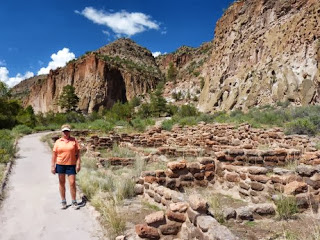
Marilyn at the ruins in Frijoles Canyon, Bandelier National Monument.  Some people lived in the valley near the river, and others in cliff dwellings above to the right.

Brad in front of Long House, a 1/4 mile long series of cliff dwelling ruins

The remaining walls of the valley village at Bandelier National Monument from the cliff dwellings

Some of the destruction caused by the floods of last week, along the Frijoles Creek near the Visitor Center at Bandelier National Monument.  Rangers say that the water rose over 13 feet!