Monday, November 5, 2012

Playing in the Slots

I say "slots" and you think "casino".  Not us - we won't visit a casino except to check out the buffet.  For those of you who know us (me especially), we don't like crowds, we don't like big cities, we prefer to be surrounded by peace and quiet and nature.  No, my friends, when I say "slots", you should think "narrow canyons".

Slot canyons are very special, and Utah has the most slot canyons in the world.  We are on our way to Capitol Reef National Park, when we decide to stop first near Goblin Valley State Park in what is identified on the map as the San Rafael Swell.  Here there are several slot canyons to hike.  First, let's talk about the State Park and the San Rafael Reef & Swell.

We visited Goblin Valley State Park three years ago, before we started RVing.  The park takes its name from the hoodoo-like formations of rock which resemble goblins.  We walked amongst these rounded rock pillars, which are about 20 to 30 feet in height.  Our plan for this trip is to visit the areas outside the state park that we missed on that first trip.

A relief map in the State Park Visitors Center shows us what the San Rafael Swell looks like if you were able to see it from the air.  It is an ancient reef which tectonic forces have thrust up at about a 45 degree angle in an oval shape about 75 miles by 40 miles.  This jagged edge of rock surrounds the swell in the center, the desert land resembling particle board that has gotten wet and swollen.  It is a bizarre sight.  On the ground, it is full of canyons, some of them slot canyons, which are defined as being significantly deeper than they are wide.  You have to be very careful when entering a slot canyon.  Rainfall many miles away can cause a flash flood though the canyon - that's how they were formed in the first place, by very fast-moving water.  We check the weather forecast and, although it's supposed to be a bit cloudy today, no rain is forecast.

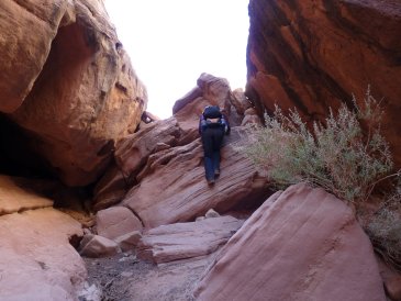
Brad & Marilyn in Little Wild Horse (slot) Canyon
We hike into Little Wild Horse Canyon which is supposed to be the narrowest and most colourful in the San Rafael Swell area.  It is fantastic.  The walls are orange stripes on crazy angles, sometimes swirling in all directions.  We are amazed at how these layers of sediments and sandstone can twist like that.  What forces nature imposes on our planet!  This realization always leaves us feeling a little insignificant.  The canyon narrows in two long stretches, at one point being only wide enough for our shoulders; in fact, we have to bend to the side to pass for about 15 feet.  At the bottom, the canyon is a V at its narrowest meaning we have to walk on the sides of the walls.  Good thing Brad's ankle has healed well, although he wears his brace today for extra support.  In several sections, we have to scramble over boulders that have wedged between the canyon walls, using our arms on the side walls to shimmy up.  These are muscle groups we haven't been using much and we are sore the next day.  Since we are in a canyon, all of the views are up or horizontal, but we are not disappointed.  We are compelled to touch the smooth sandstone which has been polished by eons of rushing water, sand and stones.  In many places, tiny caverns interrupt the smooth walls where stones or just water have whirlpooled, or the walls are rippled by some strange current.  A loop trail will take us into another canyon, Bell Canyon, but after we exit the last narrow section, we turn around and head back the way we came.  We can't get enough of a good thing!  Now we get to climb DOWN all of the wedged boulders, which is actually somewhat more difficult.  All-in-all, we hike about 5 miles - enough for me!
Brad & Marilyn in Little Wild Horse Canyon - note the water pockets in the walls
Miner's cabin ruin with Temple Mountain in the background
Some days we have surprise finds, like the day we come across the ruins at Temple Mountain and the incredible slot canyon of Crack Canyon.  Here's how it happened - we decide to drive a bit further up Temple Mountain Road where we are camping to see what's there and within a mile come to a large parking/camping area with a sign providing a description of the mining operations that occurred here from the 1880s to the 1970s.  A small town used to exist on the site where the parking lot is now, and a stone ruin up the hill has survived.  Uranium and vanadium were mined here; radium was extracted from the uranium and was sent to France for experiments done by Madame Curie - yes, THAT Madame Curie - two time Nobel Prize winner in physics and chemistry.  It is rumoured that she stayed in the stone house (pictured) that is now a ruin during a trip to see the origin of the excellent grade of ore she was receiving.  We can see the holes in Temple Mountain that were once mine shafts, with the rubble tailings spilling from the openings.  The many ATV roads here were built for the trucks that carried the mined ore out.

Cave-like holes in the wall in Crack Canyon - Brad at the bottom middle
Our map shows us that Behind the Reef Road, a dirt road traveling to the west from the parking lot at Temple Mountain, will take us to a viewpoint of the swell from the top of the reef.  Well, the views are amazing all along the road and after about 4 miles, we see a small parking lot with a sign - Crack Canyon Trailhead.  Well, why not!  We have all day!  Crack Canyon, another slot canyon of the San Rafael Reef, turns out to be better in our opinion than Little Wild Horse Canyon.  The rock of the reef is incredibly porous, resembling swiss cheese.  In one section, cave-like openings have eroded the cliff walls in two horizontal rows.  Just further along the trail the walls are full of these strangely-shaped water pockets in yellow and orange sandstone, and we have our picnic lunch in view of these.  About 1.5 miles in, there are several sections of the trail (really, the dry stream wash) which are choked with large boulders, and we have to do a lot of rock scrambling.  Some drops are about 8 feet, and we hope we can get back up.  We finally stop and turn around where the drop is about 10 feet and the bottom filled with a pool of water - we will go no further.  Scrambling back up some of the boulders we slid or climbed down is much more difficult, especially for the shorter me.  Brad has to boost me up in one place, but we make it back out.  This canyon, and the minimg ruins at Temple Mountain are unexpected, but we enjoy this day immensely.
Marilyn about to enter the "tunnel" - sides are not joined on the ceiling

Brad in Crack Canyon - very porous sandstone

Marilyn climbing down a boulder jam
Grady buried in the sand
Grady really likes our campsite, which is in a very large gravel "OHV Staging Area" (OHV=ATV) parking lot with fire rings.  We are alone most nights except on weekends and even then it's not busy.  We camp right beside Wild Horse Creek, now dry so technically a "wash" and it is very sandy.  It turns out that Grady loves the sand.  He actually lets Brad bury him in it several times, with only his head stuck out.  Crazy cat!  We don't see any snake paths in the sand, so we figure he's safe.  There are several tiny footprints that are probably from mice or Kangaroo Rats, one of which we get in the trailer for a couple of days.  We can hear him chewing on something in our storage compartment under our bedroom, and one night Grady chases something around the kitchen floor, but it gets away.  Brad finally catches it in a trap which doesn't even injure it because it's so big - as big as Brad's fist!  We let it go and don't see it again.

Oh yeah, so our "fuzzy plan" changed and we're not going to be heading back down Hwy 24 and east on Hwy 95 to Natural Bridges, Valley of the Gods and the Moki Dugway - all places where we've been before.  We'll continue to head west on 24 through Capitol Reef National Park and eventually to the Grand Staircase-Escalante National Monument, and hope the great weather holds out for the next few weeks while we hike around there.

Friday, November 2, 2012

Canyonlands' Island in the Sky

Snowcapped La Sal Mountains from our trailer spot in Moab, Utah
Before we head into Canyonlands' Island in the Sky district, we stop in Moab to stock up on supplies.  We decide to stay overnight in an actual RV Park - our first of the trip - so we can catch up on some internet work, do laundry, grocery shop, etc.  As we head to the RV Park, the skies become overcast and soon after we get set up it starts raining.  It rains for a couple of hours and while I'm at the laundromat, I look out the window and see that, not only has it stopped raining, but there is SNOW on the tops of the La Sal Mountains about 20 miles away.  It's a beautiful sight to see as the sky is clearing so there are now puffy white clouds and deep blue Utah sky!  It is quite mild down here in the valley, but it must be freezing up on those mountain tops!
Our campsite, ready for the horse trail ride
Outside of Canyonlands National Park, we find a great camping spot on free BLM land where a horse "ride" is being held in a few days.  When we get up on Saturday morning, there are about 20 horses and their families all around us readying for the trek.  They're all gone by the time we return from our daily hike.  Since we are basically alone here on a rocky plateau overlooking a valley, Grady gets his walks again.  The weather has turned very cold even though it's sunny.  Day temps barely reach 60F (16C?) and at night it hovers around freezing, so there shouldn't be any dangerous snakes about late in the day.  He is a good pet to walk, staying with me at all times, sometimes following and sometimes leading and always going back into the trailer when I clap my hands and say "Go" or tell him "In!" at the trailer steps.  He seems more content for having the exercise and activity.

Island in the Sky with La Sal Mtns (not a volcano)

In the National Park, there is lots to do and thankfully most of the trails are shorter than in the Needles District.  This area of the park is very different, looking more like a mini Grand Canyon.  You drive along through a meadow and suddenly, where the road stops, is a cliff 1,400 feet down to the next plateau which stretches away from you for several miles of nothing except small green bushes and reddish-brown sand and rock, and then another drop of perhaps another 1,000 feet to the Green or Colorado River, depending on which side of the park road you're on.  It's a stunning view pocked with buttes or a red-rock monoliths with names like Candlestick Tower, Turk's Head, Cleopatra's Chair and Washer Woman's Arch here and there.  Here's the run-down of our tour:

Upheaval Dome is a 2-mile wide depression in the rock seen from a viewpoint that we hike up to.  There are two theories on how this crater was formed.  One is that it was caused by a meteor whose impact deformed the layers of sediment and rock in the earth.  Another is that an underlying layer of salt left behind by ancient seas flowed up through the rock as it is less dense and forced the rock to heave up into a dome.  In both cases, nature then eroded the upper layers of rock, exposing the twisted layers that are visible today.  Whichever theory is true, the resulting piles of white, red and pink gravel framed by twisted red rock layers are intriguing.
Brad at Upheaval Dome, looking into the crater
Mesa Arch is a beautiful white rock arch on the edge of a cliff.  This is different from viewing the arches in Arches National Park only about 20 miles away - there you are typically standing on the ground or another rock formation from a distance looking up at an arch.  Here, we stand on the rock ledge to which the arch is attached, looking out at the valley and La Sal Mountains.  Because we are inside the arch and so close to it, we feel like we are looking through a picture frame.  Standing at the edge of the cliff (yes, we do that sometimes!) Mesa Arch looks like it is barely attached to the cliff face, there is such a large crack between it and the wall.  People walk out on top of the arch which would take very steely nerves for it's a very long way straight down.
Marilyn at Mesa Arch, framing the view into the canyon

False Kiva is a "secret" cliff dwelling at the end of a trail that is not on the park map.  It is considered a Class 2 archeological site meaning that park staff will tell you about it and how to get to it if you ask, but they will not volunteer the information.  A Class 1 site is open to the public and you will find these on maps.  A Class 3 site is so top secret that no one will tell you anything about it.  We are introduced to False Kiva from a book we purchased called "Photographing the Southwest, Volume 1 - A Guide to the natural landmarks of Southern Utah" by Laurent Martres.  It is an excellent book that tells us how to get to the locations, when it's best to photograph them (morning or afternoon light) and from where.  The beginning of the hike is easy but then, the path descends a rock cliff, makes a sharp u-turn and climbs back up the rocky cliff to the Kiva.  It is a strenuous climb down and then back up this steep switchback, but the view is extraordinarily rewarding.  From here, we are overlooking Holeman Spring Basin with a great view of Candelstick Tower and the White Rim Road about 1,400 feet below us.  The 100-mile long White Rim Road is a 4x4 road which requires a permit and 3-4 days to drive or cycle.  It mostly follows the rim of the lower plateau, above and east of the Green River and at the southern tip of the Island in the Sky District cuts across to wind through the plateau just west of the Colorado River.  Back in the Kiva, which archeologists believe wasn't really a kiva (native ceremonial place) at all but rather a circular dwelling, we wait for the afternoon sun to light up the cliffs and Candlestick Tower in front of us.  Another photographer and his wife arrive and we chat (they are from Alaska!) and we finally take some photos.  Then suddenly, about 10-12 other photographers show up!  Everyone wants to photograph the view in the late afternoon sun, as the photography book recommends.  This lighting provides for a warm glow off the kiva's red rock ceiling.  Brad and I hike it out of there, leaving the others to await sunset and a trek back in the dark, first down the rocky cliff, then across and back up.
Brad & Marilyn at False Kiva, view of Candlestick Tower
The Shafer Trail Road descends by a series of steep switchbacks down to the first plateau about 1,400 below the park road.  It is a nail-biting dirt road set on the edge of the cliff and barely wide enough for one vehicle, however this road used to be traveled by uranium ore dump trucks, so I guess we can do it in a 4x4 pick-up!  Brad makes me incredibly nervous as he's watching the scenery and, in my opinion, not focusing enough on the task at hand.  I, the passenger, never take my eyes off the road.  We are fortunate that no one is coming up the switchbacks at the same time as us, although there are tiny, tiny pull-offs where one vehicle can wait while the other passes; sometimes these are on the inside (against the cliff wall) and sometimes they're on the outside (at the edge of the cliff).  Surprisingly, a new model Mustang is descending in front of us.  Must be a rental or dad's car!  At the bottom, the road straightens out, but is still rough.  The Mustang lets us pass and we don't see him for the rest of the day.  This road becomes the White Rim Road (so named because the rock on which most of the road is built is white caprock) which we can see from the viewpoints along the park road on top.  We stop at Goosenecks Overlook which is a short trail to the cliff's edge where we have a great view of the Colorado River.  In fact, this is the best view we've seen from anywhere in the park!  The La Sal Mountains are in the background with red cliffs in the foreground, the river below edged by willows and cottonwoods, and in the middle the grey-green flat plateau.  Above us and just down river is Dead Horse Point State Park where the end of the movie Thelma and Louise was filmed.  Musselman Arch, another mile or so down the road, is similar to Mesa Arch except that the top of it is at ground level and the arch is below us.  Again, the arch is attached to the cliff wall where we stand so we look out through the arch to the scenery beyond instead of looking up at an arch in the red rock.  We can walk out on top of the arch as it is flat and about 4 feet wide at its narrowest point.  We meet several other people along the road, some like us just checking out the Gooseneck and Arch, but also cyclists who spend 3 or 4 days down here cycling the entire 100-mile White Rim Road.  They travel with at least one vehicle following behind them carrying water and supplies for the journey.  A permit is required.
Switchbacks going down the Shafer Trail Road to White Rim Road - YIKES!

Colorado River with Dead Horse Point above at the Goosenecks

Marilyn on Musselman Arch
Green River, Buck Canyon and Grand View Point Overlooks are all viewpoints of the plateaux and eroded formations in the "Monument Basin".  We can see southeast to the Needles District where we have already explored, southwest to the inaccessible (for us) Maze District, east towards Moab and the La Sal Mountains, west towards the Henry Mountains.  Of course, some views are better in the morning and others in the afternoon, as the changing position of the sun lights up the formations and creates shadows.  The views are incredible, solidifying Canyonlands as a truly unique and special place.
Brad overhanging the cliff at White Rim Overlook

The Monument Basin and White Rim Road - strange erosion at work