Monday, July 29, 2024

Phoenix Area in Arizona, January 2024

For a busy city, Phoenix has several lovely parks which we have never visited in our 13 years of exploring the southwest. So we headed east after Christmas instead of going straight to Yuma like we usually do. We found free camping just off Highway 74 (aka Lake Pleasant Road) on the east side of North New River Road. Lots of space as well as many other RV campers.

Cave Creek Regional Park


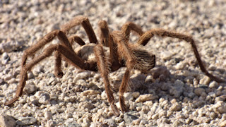
Our first hike was at Cave Creek Regional Park on the Slate Trail, to see the Michelin Saguaro. The trail was verdant with palo verde, cholla, and other desert flora.  We were told at the Visitor Center that this is one of only 3 known saguaro of this type, and no one knows why they grow this way.

We then backtracked to the connecting trail that joins to the Go John Trail, and looped back to the parking lot. The Go John Trail has wonderful views overlooking the valley and outlying cities north of Phoenix.

All trails are multi-use and we did see several other hikers, cyclists and horseback riders. It was a pretty hot day, even for January, although the elevation helped a bit. Even the horses were sweating!

White Tank Mountain Regional Park


We hiked one day at White Tank Mountain Regional Park, taking the Black Rock Trail to the Waterfall Canyon Trail. As you can see, there is no waterfall now, although a small pool at the base remained. Due to the shade, the area at the "waterfall" is incredibly cool since the rocks act like a refrigerator.

Watson Lake in Prescott


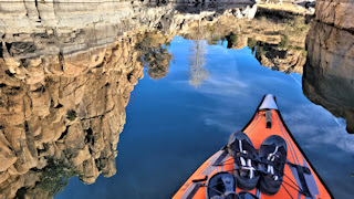
It has been 9 years since we have been to the Granite Dells, aka Watson Lake near Prescott. But this year, we have kayaks. Even though it's a one and a half hour drive north, we pack up and spend a day kayaking the lake. I'm so glad we did, as the water was so calm, great for kayaking.

We both took a lot of photos here, but sometimes you just have to sit back and enjoy the scenery as you float by.

A view of the lake and the granite rocks from the parking lot at the top of Watson Lake Park Road. The snow-capped San Francisco Mountains and Humphreys Peak above Flagstaff can be seen in the distance.

Agua Fria National Monument


We hiked a short, easy trail from I-17 (with very dangerous parking right on the side of the interstate!) to the abandoned Richinbar Mine which sits above Agua Fria Canyon within the Agua Fria National Monument. When you get to the canyon, the trail turns right or left. Follow up to the left and look on the backside of the rocks at the small peak to see petroglyphs.  The trail to the right goes to the mine.

Remnants possibly of the head frame at the Richinbar Mine site. Brad loves abandoned mines, although there wasn't much to see here. Honestly, the terrain along the trail is very open and not very interesting, although the view into the canyon is nice, and came as a surprise. I think we might have enjoyed the hike at Badger Springs, just a few more miles north on I-17, where there are also facilities and proper exit/on ramps.


Monday, July 15, 2024

Ridgecrest Area in California, December 2023

After Point Reyes, we spent most of the month of November on the California Central Coast, first at Oceano Campground in Pismo Beach State Park for 2 weeks, then at Washburn Campground in Hearst San Simeon State Park for 10 days, both the maximum allowed camping stays. I have blogged about these spots before, and we really didn't go anywhere new, so I won't repeat. We did get to visit my California cousins, so that was special. When we left Cambria and headed inland, our intention was to go to Lone Pine and the Alabama Hills to hang out for a couple of weeks before going to Lake Havasu City for Christmas. But, our truck broke down along the way, and we changed plans to have the truck fixed at a diesel shop in Ridgecrest, California. Luckily, we were never stranded, but all the fuel lines needed to be replaced, and the truck would go into a reduce power mode every time it was under strain, like when climbing the coastal mountains!

Last Chance Canyon and the El Paso Mountain Wilderness


While we waited for the parts to arrive, we found excellent BLM desert camping on Last Chance Canyon Road, between Ridgecrest and Mojave. There are designated camping areas along both sides of this dirt road at various intervals, bordered by a wooden fence to prevent people from driving all over the desert terrain. While there were always other campers nearby, we had this area to ourselves for the 2 weeks we were here.

We took a drive along Last Chance Canyon Road into the El Paso Mountains directly from our campsite. This road becomes VERY rough for a 4x4 truck, even with the tires aired down, and I vowed I was DONE with bumpy roads after this day! (I wasn't.) Our first stop was the Holly Ash Mine, an abandoned pumice mine. There were several holes dug back about 50 or so feet into the rock face.

Next we came to Bickel Camp, an historic outdoor museum now, once home to Walt Bickel. Walt built a rugged life here, 30 miles from the nearest grocery store, but with beautiful views of the mountains and canyons surrounding him.

Farther into the mountains we drove to our destination, the Burro Schmidt Tunnel. William "Burro" Schmidt was an eccentric who spent 33 years digging a tunnel through a mountain to ... nowhere! He told people he was digging the tunnel as an easier access route for ore he would mine, but he never mined even though there were some good veins of ore in the tunnel, and the tunnel, when completed, ended atop the mountain at a steep ledge overlooking the Fremont Valley.

Red Rock Canyon State Park


Not to be confused with Red Rock Canyon National Conservation Area outside of Las Vegas in Nevada, this California State Park had never been on my radar! We happened to pass by it on our way to Ridgecrest to get the truck fixed, and decided it was somewhere we had to explore. We ended up spending several days here. This formation is called Turk's Turban and is visible from the main park road, or by hiking the Hagan Canyon Trail.

More rock formations on the Hagan Canyon Trail, showing layers of sandstone and mudstone, and the difference in their erosion.

This rider was taking her horse on a walk to Nightmare Gulch from the Red Cliffs area.

From the Red Cliffs Nature Trail, we followed a trail across open desert that led to Nightmare Gulch. This view is of a side canyon.

Lake Isabella


Lake Isabella itself is a reservoir in the southern Sierra Nevada Mountains. It was a beautiful drive from our campsite, and took about one hour. After lunch on one of the beaches there, we found the Kern River, pictured here from the Keyesville River Access on Keyesville Road, where there was a kayak/canoe launch.

We are always looking for new areas to camp, and there were many dispersed campsites on both sides of the Kern River, although access could be a bit potholed. Not all sites would fit our trailer, but a few would. There were folks camping here, and they told us the area had just reopened a few weeks earlier after cleanup from damage that occurred during flooding in March 2023. This view is from one of the smaller sites that had a lovely beach.

Jawbone Canyon OHV Area


The Jawbone Canyon OHV Area is a huge area of dirt roads winding through canyons and over mountains. At least these dirt roads were better than Last Chance Canyon Road. This was the view from the top of one of the mountains on the loop drive we took.

Trona Pinnacles


We have visited the Trona Pinnacles east of Ridgecrest before, in the winter of 2013, but I wanted to repeat a couple of photos here. Brad and I had lunch overlooking these tufa formations on the loop road drive.  Note the wildflowers were already in bloom.

Right after lunch, we had a visitor who definitely seemed to know where she was going. We took many photos of her, but she paid us no attention. (I only assume it was a female, for no particular reason.)

A view of some of the pinnacles from the loop drive.  From Wikipedia ... Tufa is a variety of limestone formed when carbonate minerals precipitate out of water in unheated rivers or lakes. Geothermally heated hot springs sometimes produce similar (but less porous) carbonate deposits, which are known as travertine.